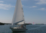
Main Ship Channel is the only deep-draft approach to Key West. Federal project depth is 34 feet from the Straits of Florida to a turning basin off the Naval Air Station Truman Annex Mole and inside the annex basin, thence 30 feet to an upper turning basin off Key West Bight, and then 12 feet to and including a turning basin in the bight. (See Notice to Mariners and latest editions of the charts for controlling depths.) The channel from the entrance to the upper turning basin is marked by lighted ranges and other aids to navigation. Spoil areas are W of the channel.
2012/04/16
Update
JB
Main Ship Channel est la seule approche à grand tirant d'eau à Key West. La profondeur est de 10,2 m au Détroit de Floride jusqu'au bassin d'évitage au large de la Naval Air Station Truman Mole et à l'intérieur du bassin annexe, environ 9 m jusqu'au bassin supérieur qui permet d'atteindre Key West Bight, puis 3,6 m y compris dans le bassin d'évitage de la baie. Le canal de l'entrée du bassin supérieur d'évitage est marqué par une fourchette éclairée et d'autres aides à la navigation. les déblais sont à l'W de la chaîne.
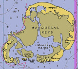
The Marquesas Keys (not to be confused with the Marquesas Islands (French Polynesia in the Pacific Ocean) form an uninhabited island group about 30 miles (50 km) west of Key West, 4 miles (6 km) in diameter, and overgrown by mangrove. They are protected as part of the Key ...
Boca Chica Key is an island in the lower Florida Keys approximately 3 miles east of the island of Key West. Its name is Spanish for "small mouth", (not "girl mouth" as many assume, since chica used as an adjective in Spanish means small).It is mainly composed of salt marshes (mangroves) ...
Stock Island is an island in the lower Florida Keys immediately east of Key West (separated from Key West by Cow Key Channel, which is only about 75 yards (70 m) wide).Immediately northwest is Key Haven (official name Raccoon Key), from which it is connected by causeway with US 1 ...
Fleming Key is an island off the northwest corner of the island of Key West, Florida in the lower Florida Keys. It is roughly 2 miles (3.2 km) long by a quarter mile wide. It is connected to the island of Key West by the Fleming Key Bridge. The island and bridge ...
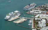
The outer anchorages, SW of Fort Taylor and about 1 mile SSE of Eastern Triangle Light, are favored by deep-draft vessels. They are somewhat exposed, but have depths of 22 to 36 feet and are safe for vessels with good ground tackle.
Pier B is another deepwater berthing facility operated by The Truman Annex Company. It has 306-foot face with a mooring dolphin at the N end; deck height about 9 feet. Maneuverable ships up to 800 feet have docked here. The Truman Annex telephone number is 305-294-4000.Outer Navy ...


 Main Ship Channel is the only deep-draft approach to Key West. Federal project depth is 34 feet from the Straits of Florida to a turning basin off the Naval Air Station Truman Annex Mole and inside the annex basin, thence 30 feet to an upper turning basin off Key West Bight, and then 12 feet to and including a turning basin in the bight. (See Notice to Mariners and latest editions of the charts for controlling depths.) The channel from the entrance to the upper turning basin is marked by lighted ranges and other aids to navigation.
 Main Ship Channel est la seule approche à grand tirant d'eau à Key West. La profondeur est de 10,2 m au Détroit de Floride jusqu'au bassin d'évitage au large de la Naval Air Station Truman Mole et à l'intérieur du bassin annexe, environ 9 m jusqu'au bassin supérieur qui permet d'atteindre Key West Bight, puis 3,6 m y compris dans le bassin d'évitage de la baie.