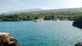
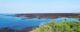
Located on the North West tip of Hawaii on the North Kohala Coast.
The harbor is identified by the lighthouse on a point just south of the anchorage and by a few houses and warehouses that are easyly visible from the water.
Anchor in sand , in 30 to 40 feet of water.
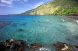
Mahukona is an excellent dive for those who have a few dives under their belt. The entry is very easy and there is a hot water shower to alleviate
the chills of an hour long dive (the shower pipe runs over the lava, and
is heated by the Sun -- very nice!). Since this is still used as a
small boat harbor, a dive flag is recommended, as always.
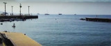
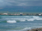
Kawaihae is a small port town along Big Island's northwestern Kohala Coast. During the 19th century, Kawaihae was a busy whaling and trading port.
Historically, Kawaihae Harbor was also the place where the ship that
brought the first horses and cattle to Hawaii docked. During the ...
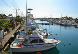
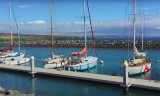
25 miles S of Kawaihae, Honokohauharbor was blasted out of solid rock and is generally considered the safest place on the big island to park a boat during heavy weather.Phone: (808) 327-3685 Fax: (808) 327 3675262 b.
The harbor is located in Kailua Bay in Kailua-Kona. The bay where you can anchor is known to local sailors as Nishihimura bay. Five and a half miles S of Upolu Point you'll see a small cove with manmade rock wall on the N face of the cliff. This wall was built for the ralroad ...
It South of Kealakechua bay. The major attrction is the historic Pu'uhonua O Honaunau, the city of refuge, wich looks much as it did hundreds of years ago.Beautiful Honaunau Bay is fronted by large, smooth, lava rock flats. Near shore the average depth is only about 10 feet. Anchor ...
La perouse bay is located south of the town of Wailea. It was named for the french Captain Jean-François de Galaup, comte de La Pérouse, in 1786. La Pérouse surveyed and mapped the prominent embayment near the southern cape of Maui opposite the island of Kahoʻolawe. The ...


 Located on the North West tip of Hawaii on the North Kohala Coast.
")
")