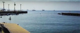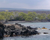

Mahukona harbor (Hawaii I)
9.8nm
335°
13 Dec 15
Joëlle
| Latitude | Longitude | |
| DMS | --- | --- |
| DM | --- | --- |
| DD | --- | --- |


")
")
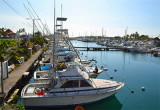
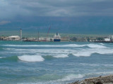
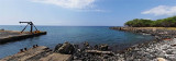
 Kawaihae is a small port town along Big Island's northwestern Kohala Coast. During the 19th century, Kawaihae was a busy whaling and trading port.
Historically, Kawaihae Harbor was also the place where the ship that
brought the first horses and cattle to Hawaii docked. During the late
1950s, Kawaihae Harbor was improved into a deep draft harbor to
accommodate more ships. Today, it is one of the largest harbors in
Hawaii. Large cargo ships arrive here, which give it more of an
industrial atmosphere.
Kawaihae is a small port town along Big Island's northwestern Kohala Coast. During the 19th century, Kawaihae was a busy whaling and trading port.
Historically, Kawaihae Harbor was also the place where the ship that
brought the first horses and cattle to Hawaii docked. During the late
1950s, Kawaihae Harbor was improved into a deep draft harbor to
accommodate more ships. Today, it is one of the largest harbors in
Hawaii. Large cargo ships arrive here, which give it more of an
industrial atmosphere.There are a few small shops, restaurants and a gas station, but not much else.
Phone: (808) 882-7565
Fax: (808) 327-3685
11 b. (North) and 25 b. (South)
Excellent protection in all weather.
Enter the harbor on N side, using the range marks and the two pair of buoys.
After you drop anchor out of the way of the commercial shipping, ask the harbor agent (his office is on the warehouse on the shipping dock) if you can use one of the moorings in the harbor.
This preferable to anchoring because there is limited space and the ships and barges require a lot of room to maneuver.
Ebook | Hawaii
|