Luka Susak

Luka Susak

To precisely geolocate this site. Update if necessary.

Localisation

Luka Susak
LatitudeLongitude
DMS------
DM------
DD------

Characteristics

Port
Restaurant

Description

Luka Susak
2008-07-16
Update
Luka Susak
2008-07-16
Update
Luka Susak
2008-07-16
Update
Ebook

Kvarner

  • 120 sites
  • 182 photos
  • publication date: 7 Jul 2023
  • .pdf file size: 69 Mb
The steeple of the village church to locate the port.
Areas of shallow overflow points N and S of the harbor.
The submerged ruins of the old breakwater extending into the NE of the end of the pier in ruins are a danger to the harbor entrance.

There are less than 1.5 m of water on these "pitfalls".
The handle of the S port is shallow.
The port is very popular with tour boats, and during the day, it may even be impossible to enter.
The large open bay on N, about 1 / 2 M in the E port is an ideal anchorage to spend the lunch hour, sandy bottom of resilience.
In the port protection is good except when I wind. Do not try to return to port by strong NE wind.
2011/07/31
Update
Jojo
Le clocher de l'église du village permet de localiser le port.

Des zones de hauts-fonds débordent des pointes N et S du port.

Les ruines submergées du vieux brise-lames s'étendant dans le NE de l'extrémité du môle en ruines constituent un danger à l'entrée du port.

Il y a moins de 1,5 m d'eau sur ces "écueils".
L'anse du S du port est peu profonde.

Le port est très fréquenté par les bateaux d'excursion, et pendant la journée, il peut même s'avérer impossible d'y pénétrer.
La grande baie ouverte au N, à environ 1/2 M dans l'E du port constitue un mouillage idéal pour y passer l'heure du déjeuner, fond de sable de bonne tenue.
Dans le port la protection est bonne sauf en cas de vent d'E. Il ne faut pas essayer de rentrer dans le port par fort vent de NE.
2011/07/31
Update
Jojo
Share your comments or photos on "Luka Susak"

Sites around Luka Susak

Flying distances - Direct line

Otok Unije

8.1nm
345°
Otok Unije, a long and irregular shaped island, lies with Rt Vnetak, its SW extremity, located 7 miles NNW of Otok Susak and at W from N O. Losinj from it is separated by Unijski Kanal.
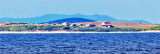
The island consists of a chain of partly wooded hills and the summit, 132m high, stands in the ...
31 Jul 11
Jojo

Olipski Kanal

19nm
111°
Olipski Kanal leads NNW between the E side of Otok Silba and the W side of Otok Olib and merges into the N end of Pohlipski Kanal.
This channel is deep and has a minimum navigable width of 0.7 mile. It is often used by vessels proceeding to and from Zadar.
Good anchorage is ...
18 Sep 11
Jojo

Otok Olib Zadar

21nm
110°
Otok Olib is located E of O. Silba. It belongs to Zadar archipelago.The island has been inhabited since Roman times. The residents bought their island in 1900. The only village on the island was established around the port.
To the east of the island you will find some small hidden ...
27 Jul 11
Jojo

Kvarnerica Vrata

14nm
112°
Kvarnericka Vrata, 5 miles wide, is the principal channel leading between the open sea and the S part of Mali Kvarneric. It lies between Otok Premuda and Otok Silba, on the S side, and Otok Ilovik, on the N side.
4 Aug 11
Jojo

Otok Premuda Zadar

17nm
128°
Premuda is located northwest of Otok Skarda which it is separated by a channel about 0.9 m wide (Premuda Vrata). The tips of each side of the channel are overwhelmed shoals and should not be approached too closely.
The coast is home to 2 W moorings and a small port and there is ...
17 Sep 11
Jojo

Otocici Srakane

3.9nm
Otocici Srakane, consisting of two narrow islets, extends up to 3.7 miles SE of the SE extremity of Otok Unije.
These islets are partly wooded and steep-to.
Hrid Silo lies close SE of the SE islet.
A light is shown from a prominent structure, 10m high, standing on this rock.
1 Aug 11
Jojo