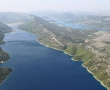
Luka Slano, entered at the NW end of Kolocepski Kanal, is a nearly landlocked inlet which provides protection from S winds. Anchorage can be taken, in a depth of 11m, near the head. The town of Slano is situated at the head of the inlet and is fronted by a quay suitable for small craft.
Vessels can also anchor off the entrance, in a depth of 50m, about 0.2 mile SW of the SE entrance point.
2011/04/25
Update
Jojo
Luka Slano, située à l'extrémité nord-ouest de Kolocepski Kanal, est une baie du littoral qui offre une protection contre les vents S. On peut mouiller, à une profondeur de 11m, au fond de la baie. La ville de Slano est située au fond de cette baie et offre un quai adapté pour les petites embarcations. Les navires peuvent également ancrer au large, à une profondeur de 50m, à environ 0,2 mile au SW du point d'entrée SE.
It is the largest and most populated island of the group Elafiten. It rises to 234 m at its N and a prominent hill rises 224 m NW of the SE end. Ruda is a small island that is 0.5 M SE of the NE extremity of the island and Misnjaka, 13 m high, lies close off the NW extremity. ...
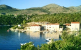
Stonski Kanal, a deep inlet, indents the SE end of Poluotok Peljesac at the NW end of Kolocepski Kanal. Its shore rises rapidly on each side and provides protection from NE and SW winds. The village of Brocej is situated on the S shore 3.8 miles within the entrance. It is fronted ...
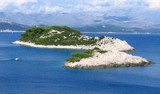
Otoc Jakljan, fronted by islets (Kosmec and Crvina) on its N side, lies close NW of the SW extremity of Otoc Sipan. A white stony peak, 225m high, stands near the center of this island and is conspicuous from seaward. Jakljan island is separated of Sipan by a narrow passage, ...
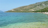
The island of Lopud belongs Elaphites. It is only 4.6 km2. It has a pleasant village and some old buildings. You'll find a sandy beach. There are two good anchorages: uvala Lopud (NW of the island), where is the village and uvala Sunj (SE of the island).
On the NW side of Slano is the tiny cove of Janska, open to the W.The village of Banica on the hill to the east, helps identify the cove from the sea. We anchored in the N by 9 m.


 Luka Slano, entered at the NW end of Kolocepski Kanal, is a nearly landlocked inlet which provides protection from S winds. Anchorage can be taken, in a depth of 11m, near the head. The town of Slano is situated at the head of the inlet and is fronted by a quay suitable for small craft.
  Luka Slano, située à l'extrémité nord-ouest de Kolocepski Kanal, est une baie du littoral qui offre une protection contre les vents S.