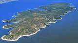
Uvala Vela Luka Korcula
6nm
265°
Easily identifiable by day or night, you can enter this great bay in all weather.
Dangers in the general approach are the ...
21 May 11
Jojo
| Latitude | Longitude | |
| DMS | --- | --- |
| DM | --- | --- |
| DD | --- | --- |


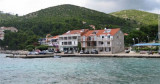
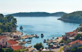
 Prigradica is a small fishing village N of Korcula, near Blato.
 Prigradica est un petit village de pêcheurs situé au N de Korcula, près de Blato.
Au fond de la baie se trouve un petit port pour petites embarcations, à côté d'une plage. A l'entrée de la baie un brise-lames et des quais peuvent procurer un abri de l'W à l'E en passant par le S.
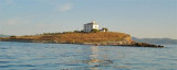
En arrivant du N Otocic Plocida (environ 4 NM au N) a un dangereux rocher près de son extrémité SE auquel il faut prendre garde.
A l'E, Hrid Blaca, rocher à 0,2 NM de la côte est signalé par une balise sans feu. A environ 1 NM à l'E de Prigradica, Hridi Naplovci (groupe de rochers bas) s'étend parallèlement à la côte. Il faut passer au N de celui-ci.
On peut s'amarrer au brise-lames.
Attention, il est interdit de mouiller dans la partie S du port et la plus grande partie du reste du port est trop profonde pour mouiller.
Ebook | Dubrovačko-neretvanska županija (Dubrovnik–Neretva
|