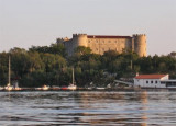
Bakarac is a bay that is more N than Kraljevica on the E coast of Bakarski Zaljev. It is a pretty village at the foot of hills covered with trees with a small shallow harbor that can't accommodate recreational boaters. We anchored outside the port by 10 m deep and take a line on the breakwater or in the N or NW of the port by 3 to 15 m deep. Good protection from all winds except the NW and Bora.
2011/07/31
Update
Jojo
Bakarac est une baie qui se trouve plus au N que Kraljevica, sur la côte E de Bakarski Zaljev. C'est un joli village au pied de pentes couvertes d'arbres avec un petit port peu profond qui ne peut accueillir les plaisanciers.
On mouille à l'extérieur du port par 10 m de fond en portant une amarre sur le brise-lames ou au N ou NW du port par 3 à 15 m de fond.
Bonne protection de tous les vents sauf du NW et de la Bora.
Tihi Kanal, 3 miles long, connects the NW end of Vinodolski Kanal to Rijecki Zaliv. The channel is deep and tortuous and leads between the mainland and the NE end of Otok Krk.
Kanal Vela Vrata connects the N end of Kvarner to Rijecki Zaliv and leads between the N end of Otok Cres, on the E side, and the mainland coast, on the W side. The channel is deep and clear, the bottom being formed of mud.
Bakarski Zaljev is a bayalmost closed on the continent, and SE of Rijeca N O. Krk. It is entered 6 NM ESE of Rijeka and is accessible by a channel of 0.3 nm wide at its narrowest point. It is equipped with facilities for cargo. There is a shipyard in Kraljevica, an oil terminal ...
Otok Plavnik lies with Rt Veli Pin, its N extremity, located 0.7 mile E of the E side of Otok Cres and divides Srednja Vrata in its S part into two channels. This cliffy island is 194m high and partly wooded. Several small islets lie on a shoal bank which extends about 1.5 miles ...
Kraljevica port is located SE of the entrance to Bakarski Zaljev. This port, near the refinery is not pleasant. A large shipyard occupies the W and S of the port and ferries use the public dock. few local boats and fishing boats are on moorings in the E port. There is very ...
Otocic Sveti Marko, barren and light-colored, lies close off the N extremity of Otok Krk and divides the N part of the fairway into two passages. The main passage leads NE of the island and is 0.2 mile wide. During strong gales, the current in this channel may attain a rate of ...


 Bonne tenue


 Bakarac is a bay that is more N than Kraljevica on the E coast of Bakarski Zaljev. It is a pretty village at the foot of hills covered with trees with a small shallow harbor that can't accommodate recreational boaters.
 Bakarac est une baie qui se trouve plus au N que Kraljevica, sur la côte E de Bakarski Zaljev. C'est un joli village au pied de pentes couvertes d'arbres avec un petit port peu profond qui ne peut accueillir les plaisanciers.