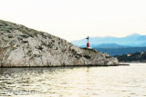
"Bakar" is the Croatian word for copper. Bakar is a port for bulk cargo and used to be known for its industrial complex.
We moored at the dock where the funds go from 0.30 to 4 m or is anchored in the harbor by 8 m. Good protection but the SE and Bora.
2011/07/29
Update
Jojo
Bakar, situé au fond de la baie bien abritée qui porte le même nom, est malheureusement un site industriel.
Bakar "est le mot croate pour le cuivre. Bakar est un port pour le fret en vrac.
On s'amarre au quai où les fonds vont de 0,30 à 4 m ou on mouille dans le port par 8 m.
Bonne protection sauf du SE et de la Bora.
2011/07/29
Update
Jojo
Share your comments or photos on "Luka Bakar Primorsko Goranska"
Kanal Vela Vrata connects the N end of Kvarner to Rijecki Zaliv and leads between the N end of Otok Cres, on the E side, and the mainland coast, on the W side. The channel is deep and clear, the bottom being formed of mud.
Tihi Kanal, 3 miles long, connects the NW end of Vinodolski Kanal to Rijecki Zaliv. The channel is deep and tortuous and leads between the mainland and the NE end of Otok Krk.
Bakarski Zaljev is a bayalmost closed on the continent, and SE of Rijeca N O. Krk. It is entered 6 NM ESE of Rijeka and is accessible by a channel of 0.3 nm wide at its narrowest point. It is equipped with facilities for cargo. There is a shipyard in Kraljevica, an oil terminal ...
Otok Plavnik lies with Rt Veli Pin, its N extremity, located 0.7 mile E of the E side of Otok Cres and divides Srednja Vrata in its S part into two channels. This cliffy island is 194m high and partly wooded. Several small islets lie on a shoal bank which extends about 1.5 miles ...
Kanal Krusija leads to the W of Otok Plavnik. This channel is frequented because of its steep-to shores and deep passage. A strong current may occasionally be experienced in this channel, depending on local weather conditions, but this passage is recommended over the one leading ...
Otocic Sveti Marko, barren and light-colored, lies close off the N extremity of Otok Krk and divides the N part of the fairway into two passages. The main passage leads NE of the island and is 0.2 mile wide. During strong gales, the current in this channel may attain a rate of ...


 Bonne tenue


 "Bakar" is the Croatian word for copper. Bakar is a port for bulk cargo and used to be known for its industrial complex.
  Bakar, situé au fond de la baie bien abritée qui porte le même nom, est malheureusement un site industriel.
Bakar "est le mot croate pour le cuivre. Bakar est un port pour le fret en vrac.
Bakar, situé au fond de la baie bien abritée qui porte le même nom, est malheureusement un site industriel.
Bakar "est le mot croate pour le cuivre. Bakar est un port pour le fret en vrac.