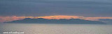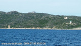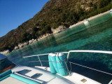

Cap Sagro - Bastia
8.9nm
70°
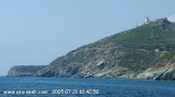
Mount Merizatodio, 778 m high, is 1.5 MN to W Cape and dominates the immediate area. The village of Erbalunga, situated 1.5 miles SSW of Capo Sagro, stands on the S ...
6 May 12
Jojo
| Latitude | Longitude | |
| DMS | --- | --- |
| DM | --- | --- |
| DD | --- | --- |


Ebook | Corse - Corsica
|
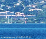
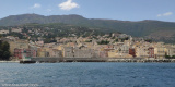
 The Gulf of Saint Florent form a large body of water open to the North to NW winds, but sheltered by the mountains Libeccio of Balagne.
The clear waters and the presence of many fish make it particularly attractive diving near the edge Vecchiaja between 5 and 30m.
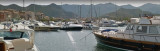
In 1440, the Genoese erected on this site a citadel which remained until the eighteenth century, the seat of the bishopric of Nebbio and Government House. Despite the ravages of malaria, there was disputed in the sixteenth century by the French, Genoese, and of course, the Corsicans.
The city found a new lease, after Napoleon III had ordered the draining of marshes, thus addressing the root causes of malaria. Planning work was begun and were continued under the Third Republic.
The creation of a marina in 1971 contributed greatly to the growth of the city.

 Le golfe de Saint Florent forme un vaste plan d'eau ouvert aux vents de Nord à NW, mais bien abrité du Libeccio par le massif montagneux de la Balagne.
Les eaux claires et la présence de nombreux poissons rendent particulièrement attractive une plongée aux abords de la pointe Vecchiaja entre 5 et 30m.
En 1440, les Génois édifièrent sur ce site une citadelle qui resta, jusqu'au XVIII ème siècle, le siège de l'évêché du Nebbio et la résidence du gouverneur. Malgré les ravages provoqués par la malaria, cet endroit fut disputé au XVI ème siècle par les Français, les Génois, et bien entendu, les Corses.La ville trouva un nouvel essor, après que Napoléon III eut ordonné l'assèchement des marais, s'attaquant ainsi aux racines du paludisme. Des travaux d'urbanisme furent entrepris et se prolongèrent sous la IIIème République.
La création d'un port de plaisance en 1971 a contribué grandement à l'essor de la cité.