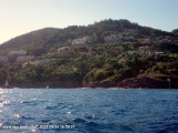
Easy access to the harbour except in wind from the E. Harbourg sheltered from all winds. Landmark: The N mont "San Peyre" (131 m) from 1 M to the N. 183 berths (<13 m)
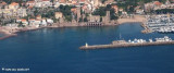
Marina positioned at the W end of La Napoule bay extending from Pointe de l'Aiguille (needle's point) to that of the Croisette (E of La Napoule castle. The anchorage in the marina is forbidden. Marina sheltered from all winds. 780 berths incl. 180 visit.
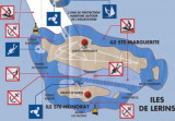
Ile Saint-Marquerite, the bigest island close to the city of Cannes, lies centered 1 mile SSE of Cap de la Croisette and is very wooded. A conspicuous citadel, in which there is a disused signal station, stands near the middle of the N coast of the island. A small shipyard is situated ...
Access by Siagne river 0,5 M E of Mandelieu. La Napoule Port, passing under two bridges (maximum draught under Siagne bridge 4 m. Landmarks: Royal Casino Hôtel (white building) 50 m to port of the mouth of Siagne. 1730 berths (<12m), no berths for visit. Anchoring forbidden in port.
Situated 5 M SW of Cannes between Pte de la Galère and Pte St-Marc. Access: Trough a narrow passage, seawall to S, rocks to N. 174 berths (<12 m) incl. 18 visit.


 Vue vers le viaduc de chemin de fer, amer remarquable.
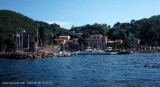
 Harbour well protected from NW wind ( Mistral). In the rear a huge railaway viaduc with 6 red brick arches, landmark lit at night.
 Port bien abrité du Mistral. Au fond un viaduc SNCF de 6 arches en briques rouges crée un amer remarquable de jour comme de nuit.
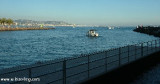
 Feux de Musoir de l'entrée de la Rague