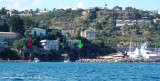
Feu de musoir vert à l'entrée du port. 2006-10-08°
2007-07-11
Update
Mobile
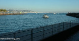
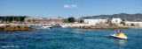
Le port avec sur babord la capitainerie (batiment rond). Sur l'arrière se trouve une pompe à essence. A terre toute les facilités de commerce. 2006-10-08 Bearing:30°
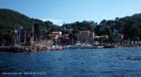
Marina positioned at the W end of La Napoule bay extending from Pointe de l'Aiguille (needle's point) to that of the Croisette (E of La Napoule castle. The anchorage in the marina is forbidden. Marina sheltered from all winds.
780 berths incl. 180 visit.
2007/11/20
Update
Port situé au NW du golfe de la Napoule devant le chateau de la Napoule. Le mouillage en rade est interdit. Marina abritée de tous les vents.
780 places dont 180 pour le passage.
T. 04 92 97 77 77
F. 04 92 97 78 78
2007/11/20
Update
2007-11-20
Update
Share your comments or photos on "Port de la Napoule"
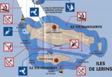
Ile Saint-Marquerite, the bigest island close to the city of Cannes, lies centered 1 mile SSE of Cap de la Croisette and is very wooded. A conspicuous citadel, in which there is a disused signal station, stands near the middle of the N coast of the island. A small shipyard is situated ...
Harbour well protected from NW wind ( Mistral). In the rear a huge railaway viaduc with 6 red brick arches, landmark lit at night. 424 berths (<30m) incl. 104 visit.
Access by Siagne river 0,5 M E of Mandelieu. La Napoule Port, passing under two bridges (maximum draught under Siagne bridge 4 m. Landmarks: Royal Casino Hôtel (white building) 50 m to port of the mouth of Siagne. 1730 berths (<12m), no berths for visit. Anchoring forbidden in port.
Easy access to the harbour except in wind from the E. Harbourg sheltered from all winds. Landmark: The N mont "San Peyre" (131 m) from 1 M to the N. 183 berths (<13 m)
At the E Siagne mouth, small port at the Béal stream enter, the shelter is not good when E winds. 500 berthsA prohibited anchorage area extends from Port Abri du Beal to Le Vieux Port.


 canal 9


 2006-08-17
 Feu de musoir vert à l'entrée du port.
 Le port avec sur babord la capitainerie (batiment rond). Sur l'arrière se trouve une pompe à essence. A terre toute les facilités de commerce.
 Marina positioned at the W end of La Napoule bay extending from Pointe de l'Aiguille (needle's point) to that of the Croisette (E of La Napoule castle. The anchorage in the marina is forbidden. Marina sheltered from all winds.
 Port situé au NW du golfe de la Napoule devant le chateau de la Napoule. Le mouillage en rade est interdit. Marina abritée de tous les vents.