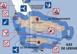
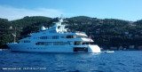
Ile Saint-Marquerite, the bigest island close to the city of Cannes, lies centered 1 mile SSE of Cap de la Croisette and is very wooded. A conspicuous citadel, in which there is a disused signal station, stands near the middle of the N coast of the island. A small shipyard is situated ...
Easy access to the harbour except in wind from the E. Harbourg sheltered from all winds. Landmark: The N mont "San Peyre" (131 m) from 1 M to the N. 183 berths (<13 m)


 canal 9


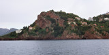
 Situated 5 M SW of Cannes between Pte de la Galère and Pte St-Marc.
 Port situé à 5 M au SW de Cannes entre la Pointe de La Galère et la Pointe St-Marc.