
Iles de Lerins - Saint Honorat
0.8nm
193°
18 Jan 12
dd
| Latitude | Longitude | |
| DMS | --- | --- |
| DM | --- | --- |
| DD | --- | --- |


Ebook | Côte d'Azur - French Riviera
|
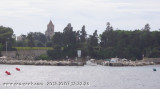
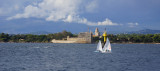
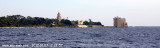
 Ile Saint-Marquerite, the bigest island close to the city of Cannes, lies centered 1 mile SSE of Cap de la Croisette and is very wooded. A conspicuous citadel, in which there is a disused signal station, stands near the middle of the N coast of the island. A small shipyard is situated close W of this citadel.
A shoal, with a depth of 8.6m, lies about 0.3 mile NW of the beacon and the sea breaks on it during S winds. The E extremity of the island has the ruins of a battery standing close WSW of it. A low islet lies close E of this point and is connected to it by a ridge of rocks.
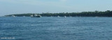
Speed limit to 5 knots around the islands.
 La plus grande des deux iles et la plus près de Cannes. Dans sa partie Nord un fort et un chantier naval. Le mouillage est possible au Nord- Ouest, Nord - Est et entre les iles. Bien respecter le balisage et en particulier l'accès aux iles réservé aux bateaux de transport de passagers.
Attention la vitesse est limitée (5 noeuds) autour des iles.
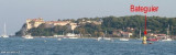
La Pointe Batéguier, extrémité Ouest de l’île, porte une tour en maçonnerie. Elle est débordée au Nord par le Plateau de la Jonquière, à fleur d’eau et balisée à l’Ouest par deux bouées cardinales lumineuses, mouillées de part et d’autre de la tourelle « Batéguier » peinte en blanc. La Bronde de Batéguier est un haut-fond couvert de 8,6 m d’eau, situé à 0,2 M à l’WNW de la tourelle précédente et sur lequel la mer brise par vents de Sud.