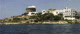
La Punta is the NE end of S. Pietro island. The N end of the island is rocky, low and flat on wich we see a tunny fishery.
Even today you can see a "matanza" the old style. You can ask permission to the factory to see the show.
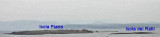
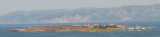
NE of Punta is Piana island and dei Ratti island. There is a private marina on Piana island. You can ask an permision to stay one night.
2012/10/28
Update
Joëlle
La Punta, est l'extrémité NE de l'île S. Pietro. C'est un promontoire rocheux, bas et plat sur lequel on voit une usine de conserves de thon. Encore aujourd'hui on peut voir une "matanza" au vieux style. On peut demander l'autorisation à l'usine pour voir le spectacle.
Au NE de la Punta on voit l'île Piana et l'îlot dei Ratti. Il y a une marina privée sur l'île Piana. On peut demmander une permision pour rester une nuit.
2012/10/28
Update
Joëlle
La Punta, è l'estremita N dell'isola di S. Pietro.L'estremita N dell'isola di S. Pietro è un promontorio roccioso, basso e piato su il quale si vede una fabbrica di tonno in scatola. Ancora oggi è possibile vedere un "matanza" il vecchio stile. È possibile chiedere il permesso alla pianta a vedere lo spettacolo.
NE dalla Punta si vede l'isola Piana e l'isola dei Ratti. C'è un porto turistico privato sull'isola Piana. Si può richiedere una autorizzazione per soggiornare una notte.
2012/10/27
Update
Joëlle
La Punta
2012-10-28
Update
Joëlle
Share your comments or photos on "La Punta di S. Pietro (Sardegna)"
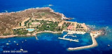
Piana island is part of archipelago del Sulcis. It is located NE tip of San Pietro (located on the island of the same name).On the island is the "Residence Villamarina" residential area which covers the entire island. The island is private and to access you must go to the office ...
The islet is private. On the SE coast is a small private port (Villamaria) with a small beakwater. 77 b. <20 m Depth: <1 - 2,5m tel.: 0781 854460 fax: 0781 854954
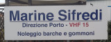
Marina Sifredi, SW Sardinia, is on the E side of Isola di San Pietro, close to the only town on the island, Caloforte. Marina Sifredi has two marinas located respectively in the North and South of Caloforte harbour. Sifredi marina is in the N and S area of Caloforte harbour. Mamma ...
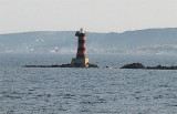
Scoglio La Ghinghetta lies 1 NM of Portoscuso entrance and is surrounded by rocks. A light is shown from a tower, 10 m high, standing on this rocky shoal.Several shoal patches, with depth of 3 to 7 m lie about 1,6 NM WNW of the light and are marked by a lighted buoy.
Portoscuso tower lies on a hill overlooking the small maritime town, including the small Ghinghetta cove and the cliff of Port Paleddu. Strategic location from wich you can maintain eye contact with the other coastal towers (Calasetta and Carloforte).


")
")
")
")
") La Tonnara
La Tonnara La Punta is the NE end of S. Pietro island. The N end of the island is rocky, low and flat on wich we see a tunny fishery.
 La Punta, est l'extrémité NE de l'île S. Pietro. C'est un promontoire rocheux, bas et plat sur lequel on voit une usine de conserves de thon. Encore aujourd'hui on peut voir une "matanza" au vieux style. On peut demander l'autorisation à l'usine pour voir le spectacle.
 La Punta, è l'estremita N dell'isola di S. Pietro.L'estremita N dell'isola di S. Pietro è un promontorio roccioso, basso e piato su il quale si vede una fabbrica di tonno in scatola. Ancora oggi è possibile vedere un "matanza" il vecchio stile. È possibile chiedere il permesso alla pianta a vedere lo spettacolo.
") La Punta
La Punta