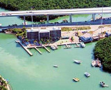
From the Ocean take Hawks Channel to Red Marker Number 32. From Marker go to the sunken barge and follow the Channel to Channel Marker Green 19 and turn right into Garden Cove Canal. The marina is at the end of canal. Garden Cove Marina is on a saltwater canal providing access to the Atlantic Ocean.
Tel: 305-451-4694 14 slips
2010/03/30
Update
soja
En venant de l'Océan, prendre Hawks Channel au marqueur rouge numéro 32. A partir du marqueur aller à la barge submergée et suivre le marqueur vert 19 du canal. Tourner à droite dans Garden Cove canal. La marina se trouve à la fin du canal, sur un canal d'eau de mer donnant accès à l'Océan Atlantique.
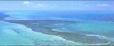
The first underwater park in the U.S., John Pennekamp Coral Reef State Park encompasses approximately 70 nautical square miles. It is the coral reefs and their associated marine life that bring most visitors to the park. Many enjoy the view of the reef from a glass-bottom ...
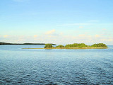
Elliott Key is the northernmost of the true Florida Keys (those 'keys' which are ancient coral reefs lifted above the present sea level), and the largest key north of Key Largo. It is located entirely within Biscayne National Park. It is bordered by the Atlantic Ocean to ...
Key Largo Dry Rocks lies within the boundaries of the previous Key Largo National Marine Sanctuary.Key Largo Dry Rocks is located seaward of White Banks and extends to an approximate depth of 30 feet. Dry Rocks SPA covers an area of approximately 0.05nm2, or about 16ha, and ...
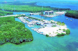
The Anchorage Resort and Yacht Club is in Key Largo, flanks the easterly shores of Jewfish creek, opposite Gilbert?s Resort Marina.Tel: 305 451 0500 Minimum depth: 6'
Gilbert's Marina is the first boat gas station entering the Florida Keys or the last, leaving the Islands. Being located at the Intracoastal Waterway, Gilbert's makes a great stop for Poker Runs and Regattas. Tel: 305 451 1133 Fax: 305.451.4362 Email: gilbertspi2@aol.com Minimum ...
In the Key Largo Area are Mosquito Banks, at a short distance from the Pennekamp Coral Reef State Park. Mosquito Bank overlies a concave low-elevation indentation or reentrant in the bedrock depression beneath Hawk Channel. Sediments in Mosquito Bank are mostly muddy sands with ...


")
")