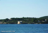
Maddalena or Maddalenetta islet is marked by a light, 0,9 NM from Alghero. It is a red rockof 4 m high. It extends to SW with less than 5,5 m of water.
Anchorage is available, in a depth of 20m, about 0.7 mile W of Isolotto della Maddalena.
2012/11/16
Update
Joëlle
L'îlot La Maddalena ou Maddalennetta, est signalé par un feu, à 0,9 MN d'Alghero. C'est un rocher rouge de 4 m de haut. Il est prolongé par des rochers sur son côté SW qui se trouvent à moins de 5,5 m d'eau. On peut mouiller par 20 m, à environ 0,7 MN à l'W de l'îlot.
2012/11/16
Update
Joëlle
L'isolotto La Maddalena o Maddalennetta, è segnalato da uno faro a 0,9 MN di Alghero. Si tratta di una roccia rossa di 4 m de altezza. Si estende sul lato SW dove sono meno di 5,5 m di acqua.
Si puo ancorare in 20 m, a circa 0,7 MN da isolotto Maddalena.
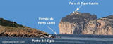
The park begins at Capo Galera to continue toward the gulf of Porto Conte that is protected by two promontories, Punta Giglio and Capo Caccia-Monte Timidone. The marine protected area embraces the stretch of sea to the north-west of Punta Cristallo.Almost all of the park consists ...
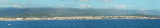
Rada di Alghero is entered between S, the town of Alghero and N, capo Galera.The E shore of this bay is low and sandy, and the W shore is hilly and rocky. An undulating coastal plain, partly under cultivation, lies immediately inland of the head of this bay.This bay is open to ...
Porto Conte is a natural bay between Punta del Giglio and Caccia cape.Along E shore of the bay, on a projecting point, we see Porto Conte village, with the tower Nuova, which is backed by a turret with a light.You can anchor anywhere. The bay offers shelter from all winds. Mount ...
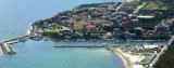
Alghero is part of the "Riviera del Corallo", famous for its red corals. Beautiful city where 60% of people still speak an archaic Catalan and Italianate, the" Alguérois". Alleys, promenade along the sea on the walls. The port is divided into many concessions, so discussions!
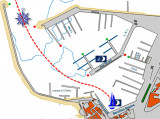
Located at the mouth of the canal that unites the bay of Alghero with Calich pond. The harbor is well protected but the depth does not exceed 3 m.There is no particular problem in the approach. The only wind that created difficulties at the entrance of this small port is the Libeccio ...
Spanish tower Lazzaretto (XVII century) stands on the right and low rocky promontory overwhelmed by low cliffs, bordering, S, Lazzaretto cala. It is private.Anchor in 14 m off the beautiful Lazzaretto beach


 good holding

 Maddalena or Maddalenetta islet is marked by a light, 0,9 NM from Alghero. It is a red rockof 4 m high. It extends to SW with less than 5,5 m of water.
 L'îlot La Maddalena ou Maddalennetta, est signalé par un feu, à 0,9 MN d'Alghero. C'est un rocher rouge de 4 m de haut. Il est prolongé par des rochers sur son côté SW qui se trouvent à moins de 5,5 m d'eau.
 L'isolotto La Maddalena o Maddalennetta, è segnalato da uno faro a 0,9 MN di Alghero. Si tratta di una roccia rossa di 4 m de altezza. Si estende sul lato SW dove sono meno di 5,5 m di acqua.
")
")
")