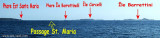
These islets lie at 1.5 NM E Coticcio tip on the E side of Caprera island. They are low and clear.
A turret gray light, stands on most SE islet.
The shoal of Monaci, covered with 2.8 m of water, is about 1 NM, E from the islets. It is marked by a red buoy with seeing spherical and covered by a colored at night by the lights of Monaci islets and Ferro Cape.
2012/11/28
Update
Joëlle
Ces îlots gisent à 1,5 MN à l'E de la pointe Coticcio, sur la côte E de l'île Caprera. Ils sont bas et de couleur claire.
Une tourelle grise, lumineuse, s'élève sur l'îlot le plus au SE.
Le haut-fond des Monaci, couvert de 2,8 m d'eau, est à 1 MN environ, à l'E des îlots. Il est balisé par une bouée rouge à voyant sphérique et couvert de nuit par un secteur coloré des feux des îlots Monaci et du cap Ferro.
2012/11/28
Update
Joëlle
Questi isolotti sono a 1,5 MN all'E della punta Cotticcio, sulla costa E dell'isola Caprera. Sono bassi e di colore chiara.
Una toretta grigio, luminosa, si erge sull'isolotto il piu a SE.
Il banco di Monaci, ricoperto di 2,8 m d'acqua, è di circa 1 MN, all'E dei isolotti. E 'caratterizzato da una boa rossa a vedere sferica e coperta da notte da un zona coloratadi luci dalle isole Monaci e Capo Ferro.
It is the largest island of the archipelago composed of sixty islets and 7 major islands, in the NE end tip of Sardinia. It is mountainous and arid. This is the only inhabited island thoroughly. It is connected by a bridge to Caprera island where are the house and the tomb of Garibaldi. ...
Gulf of Arzachena (Arsachena), located between Punta Saline and Tre Monti Cape, is a high inlet whose banks are lined with shoals. S tip, Arzachena, W of the entrance, a beacon consists of an iron post with a sheer spherical white marks a rock particularly ...
La tourelle Pecorella marque l'entrée de ce golfe qui s'enfonce à plus de 4 M dans les terres. Celle de Chiapino qui était plus au S est démolie. Il faut donc remonter suffisamment vers le N pour ne pas risquer d'en toucher les restes. En piquant vers l'W, la balise noire délimite ...
SW of Corsica offers some of the most beautiful anchorages. As you get closer to Bonifacio be carreful with the weather forecast as the NW wind can be very strong.
The range of the tide in this area is negligible. There are no regular currents along the coasts of Corse, ...


 These islets lie at 1.5 NM E Coticcio tip on the E side of Caprera island. They are low and clear.
 Ces îlots gisent à 1,5 MN à l'E de la pointe Coticcio, sur la côte E de l'île Caprera. Ils sont bas et de couleur claire.
 Questi isolotti sono a 1,5 MN all'E della punta Cotticcio, sulla costa E dell'isola Caprera. Sono bassi e di colore chiara.
")