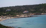
San Pietro island is SW of Sardegna. Caloforte is the only town and the only harbour of the island.
San Pietro island is fairly flat in the S, it is higher in the center and rugged in the center and N. SW coast of the island is rugged and arid. It is very indented and form numerous small bays. It is generally unhealthy. The E coast of Isola di San Pietro is low, sandy, and fringed with numerous shoals.
2012/10/28
Update
Joëlle
L'île de San Pietro se trouve au SW de la Sardaigne. Caloforte est la seule ville et le seul port de l'île.
L'île de San Pietro est assez plate dans la partie S, elle est plus
élevée et accidentée au centre et au N. La côte SW de l'île est escarpée
et aride. Elle est très découpée et forme de nombreuses petites baies.
Elle est en général malsaine. La côte E est basse, sablonneuse, et débordée par de nombreux hauts-fonds.
2012/10/28
Update
Joëlle
L'isola di San Pietro è al SW dalla Sardegna. Caloforte è la sola citta e il solo porto dell'isola.
L'isola di San Pietro è abbastanza piata in S, è più alta al centro e robusto e al N. La costa SW dell'isola è aspra e arida. E 'molto tagliata e forma numerose piccole baie. È generalmente malsano. La costa E è bassa, sbbiosa, e sopraffatto da numerose secche.
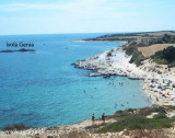
Spalmatore Grande Baia is between Spalmatore di Fuori Point and Dei Cannoni Point. In the bay, at Starboard on entering, is a small cove called Caletta. Anchor in 3 to 10 m.
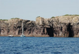
Mezzaluna gulf is between Grossa point and Buemarino point, W of Genia. This beautiful gulf is surrounded by red rocks 30/35 m high. In the fissures of the rocks we can see the entrance of the caves.You can anchor in 12 to 14 m in the middle of the bay.
At about 600 m from the shore, it must be very careful at a small shoal barely touches the water and that should keep well offshore. The seabed in this area are low, around 5 m, and fell rapidly to about 25 m.
Even the small island of Genia, which emerges near the center of ...
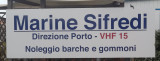
Marina Sifredi, SW Sardinia, is on the E side of Isola di San Pietro, close to the only town on the island, Caloforte. Marina Sifredi has two marinas located respectively in the North and South of Caloforte harbour. Sifredi marina is in the N and S area of Caloforte harbour. Mamma ...
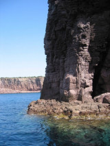
Punta delle Colonne, S end of S. Pietro island. It is is the most southern tip of the island, and it marks the beginning of the rocky part of the island. In fact, although not higher than 20 meters, the walls of rocks fall into the sea with an impressive verticality.


 San Pietro island is SW of Sardegna. Caloforte is the only town and the only harbour of the island.
 L'île de San Pietro se trouve au SW de la Sardaigne. Caloforte est la seule ville et le seul port de l'île.
 L'isola di San Pietro è al SW dalla Sardegna. Caloforte è la sola citta e il solo porto dell'isola.
")