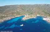


Area Marina Protetta di Capo Caccia - I. Piana (Sardegna)
27nm
188°
20 Nov 12
Joëlle
| Latitude | Longitude | |
| DMS | --- | --- |
| DM | --- | --- |
| DD | --- | --- |


")
")
")
Ebook | Sardegna North West
|
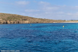
 Asinara is the second largest island of Sardinia after Sant'Antioco. A Marine Reserve was created arounds the island and the Fornelli passage.
It is a narrow territory stretching from North to South, with a very indented coastline, which highlights the great variety of habitats.
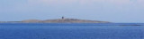
The W coast of the island is inaccessible and barren. The E coast is partly rocky, partly sandy, and fringed with rocks, except along the NE part which is generally steep-to.
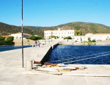
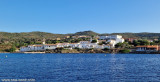
The buildings of a penal colony are situated on the N side of Cala d’Oliva, which is entered 2.5 miles SSE of Punta Caprara.
The island has an extremely peculiar historical, environmental, and juridical situation. Although the first evidences of human presence date back to the Neolithic Age, the environmental features of the area have been preserved thanks to a series of events which gave it the name of "Isola del Diavolo" ("Devil's Island"): it was a health center of quarantine, a camp of imprisonment during World War I, and one of the most important Italian superprisons during the terroristic period of the 70s and during the struggle against the organized crime, until the Park was established.
This more than a century long isolation led on the one hand to the creation of the island's aura of charm and mystery, and on the other hand to the indirect conservation of some integral and virgin areas which transformed it into an international unique and invaluable heritage.
'' The island houses a penitentiary, so it is forbidden to dock and anchor near the coast. "
Against, the'' 'Rada della Reale''' is excellent shelter against Mistrale.
 Une réserve marine entoure l'île, y compris le passage de Fornelli. Cette ïle a été déclarée Parc Nationnal.
L'Asinara, deuxième île en Sardaigne après Sant'Antioco, présente une forme étroite et allongée en direction Nord-Sud; ses côtes sont très découpées, ce qui est l'indice d'une extraordinaire variété d'habitats.
Cet isolement de plus d'un siècle a favorisé d'un côté la naissance du charme et du caractère mystérieux de l'île, et de l'autre, bien que de façon indirecte, la préservation de quelques aires vierges, ce qui fait de l'île un patrimoine unique et à la valeur inestimable au niveau international.
Ebook | Sardegna
|
 L'Asinara (area marina protetta), per dimensioni la seconda isola sarda dopo Sant'Antioco, presenta una forma stretta, allungata in senso Nord-Sud con un andamento della linea costa molto frastagliato, indice di una notevole varietà di habitat.
 La costa W dell'isola è inaccessibile e sterile. La costa E è in parte rocciosa, in parte sabbiosa e orlata di scogli, ad eccezione lungo la parte NE che è generalmente ripido. Gli edifici di una colonia penale sono situati sul lato N di Cala d'Oliva, situato 2,5 miglia SSE di Punta Caprara.
L'Isola presenta una situazione storica, ambientale e giuridica estremamente singolare. Sebbene i primi resti della presenza umana risalgano al neolitico, la natura si é potuta conservare grazie ad un susseguirsi di eventi che le fecero assumere il nome poco accattivante di Isola del Diavolo: è stata una Stazione Sanitaria di quarantena, un campo di prigionia nella prima guerra mondiale ed uno dei principali supercarceri italiani durante il periodo del terrorismo degli anni '70 e nella lotta contro la delinquenza organizzata sino all'istituzione del Parco.
Questo isolamento, durato oltre un secolo, ha provocato da un lato la nascita del fascino e del mistero dell'Isola e dall'altra l'indiretta conservazione di alcune aree integre e vergini, rendendola un patrimonio unico e di inestimabile valore a livello internazionale.
'' L'isola ospitando un penitenziario, è divieto di dock e anchor vicino alla costa. "
Contro il'' 'Rada della Reale''' è ottimo riparo contro Mistrale.