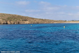
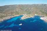
Trabuccato point, dominated by a tower, forms the NE end of the harbor Delle Reale, large bay that the hollow central part of the island Asinara and where we find one of the best moorings existing on the coast of Sardinia. CORRECTION Navigation Marine Reserve Mooring prohibited in a strip of 1M around the island (see guide imray2008)
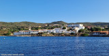
On the N shore of the harbor facilities of an hospital are divided into three groups of buildings. Two small jetties extend in front of the group W and three mooring buoys are wet along the coast. In the N of the harbor, opposite the medical station, or the reef Scoglietti Scogli Neri carrying several black rocks, extends over a length of about 1M. A white light tower marks its NW end and a bright white and red buoy the SE end.
2012/08/29
Update
Joëlle
2012-08-29
Update
Joëlle
La pointe Trabuccato:
La pointe Trabuccato, dominée par une tour, forme l'extrémité NE de la rade Delle Reale, vaste baie qui creuse la partie centrale de l'île Asinara et où l'on trouve l'un des meilleurs mouillages existant sur la côte de Sardaigne. RECTIFICATION réserve marine mouillage navigation interdits dans une bande de 1M autour de l'île ( cf guide imray2008)
Sur la rive N de la rade les établissements d'un hôpital sont répartis en trois groupes de constructions. Deux petits appontements s'étendent en face du groupe W et trois bouées d'amarrage sont mouillées le long de la côte. Dans la partie N de la rade, en face de la station sanitaire, le récif Scoglietti ou Scogli Neri portant plusieurs rochers noirâtres, s'étend sur une longueur de près de 1M. Une tourelle blanche lumineuse en marque l'extrémité NW et une bouée rouge et blanche lumineuse l'extrémité SE.
2012/08/29
Update
Joëlle
2012-08-29
Update
Joëlle
La punta Trabuccato: Il Trabuccato punta, dominata da una torre, costituisce la fine NE del porto Delle Reale, grande baia che la parte centrale cava del all'isola dell'Asinara, e dove troviamo uno dei migliori ormeggi esistenti sulla costa della Sardegna.
CORREZIONE Navigation Marine Reserve Ormeggio vietato in una striscia di 1M in tutta l'isola (vedi guida imray2008)
Sulla riva N delle infrastrutture portuali di un ospedale sono divisi in tre gruppi di edifici. Due piccoli moli estendersi in avanti del gruppo W e tre boe di ormeggio sono bagnati lungo la costa. Nel N del porto, di fronte alla stazione medica, o la barriera corallina Scoglietti Scogli Neri portando diverse rocce nere, si estende su una lunghezza di circa 1M. Una torre di luce bianca segna la sua fine NW e una boa luminose bianche e rosse la fine SE.
The park begins at Capo Galera to continue toward the gulf of Porto Conte that is protected by two promontories, Punta Giglio and Capo Caccia-Monte Timidone. The marine protected area embraces the stretch of sea to the north-west of Punta Cristallo.Almost all of the park consists ...
SW of Corsica offers some of the most beautiful anchorages. As you get closer to Bonifacio be carreful with the weather forecast as the NW wind can be very strong.
The range of the tide in this area is negligible. There are no regular currents along the coasts of Corse, ...
Véritable bijoux. Sauvage pas habitation. Une petite route avec 2 voitures par heure. Belle végétation de maquis plus montagne. Ânes y compris albinos qui braient jour et nuit. Poissons qui nagent avec vous. 8 bouées cordage neuf plots béton. Seul pas de bateau.
Oliva cove, located NE Asinara island, is recognizable by the remarkable constructions of the penal colony. A round tower stands on the tip of the loop S. Cala d'Oliva was a military outpost since 1550, as evidenced by the old maps, was protected by an Aragonese tower and ...
The cove Delle Reale, large bay that hollow central part of the island Asinara and where there is one of the best existing anchorages on the coast of Sardinia. CORRECTION marine reserve mooring navigation banned in 1M tape around the island (see guide imray2008).
It ...
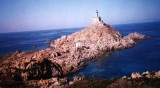
Caprara (or del Scorno) point, N tip of Asinara island, has a lighthouse, house with two floors on which rises a high round tower, painted white. The point is overwhelmed at N by shoals. At about 0.5 M SSW from the lighthouse, at 120m high, we see the old semaphore, low, ...


 Trabuccato Point:
")
 La pointe Trabuccato:
")
 La punta Trabuccato:
")