Isola La Maddalena (Arcipelago della Maddalena)
4.9nm
145°
It is connected by a bridge to Caprera island where are the house and the tomb of Garibaldi. ...
26 Nov 12
Joëlle
| Latitude | Longitude | |
| DMS | --- | --- |
| DM | --- | --- |
| DD | --- | --- |

 Parco Nazionale della Maddalena
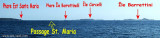
 Leaving Corsica up to the Lavezzi islands, the island Razzoli is the first island north Sardinia encountered. An old square lithouse next to the new lighthouse on the NW tip is very remarkably.
Razzoli is an island of the Archipelago of La Maddalena located at the northern end of Sardinia near the Straits of Bonifacio. It is with the other islands of the archipelago, the National Park of the Archipelago of La Maddalena.
Razzoli island has an area of 1, 5 km ² and has 12.3 km coastal development. The highest peak is Monte Cappello which rises to 65 meters above sea level. The island is separated a few meters from the island of Santa Maria in the "Passo Asinelli."
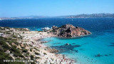
His appearance differs little from that of neighboring islands because of the high rocks but the few beaches on the island are known for their beauty as Cala Lunga, Cala Cappello, or Cala delle Noce.
West Coast offers two ancorages, the Cala Longa and the loop between Razzoli and the neighboring island of Budelli. Both anchorages are open to swell and westerly winds frequent on this coast.
 En quittant la Corse à la hauteur des iles Lavezzi, l'île Razzoli est la première des îles de nord Sardaigne rencontrée. L'ancien phare de forme carrée et le nouveau phare sur la pointe NW sert d'amer remarquable.
Razzoli est une île de l'Archipel de la Maddalena située à l'extrémité nord de la Sardaigne près des Bouches de Bonifacio. Elle constitue avec les autres îles de l'archipel, le Parc National de l'Archipel de la Maddalena.
L'île de Razzoli a une superficie d'1,5 km² et dispose d'un développement côtier de 12,3 kilomètres. Le sommet le plus haut est le Monte Cappello qui culmine à 65 mètres au dessus du niveau de la mer. L'île est séparée de quelques mètres de l'île de Santa Maria par le "Passo degli Asinelli".
Son aspect diffère un peu de celui des îles voisines à cause des hauts rochers mais le peu de plages présentes sur l'île sont connues pour leur beauté comme la Cala Lunga, la Cala Cappello ou encore la Cala delle noce.
La côte Ouest offre deux mouillages, la Cala Longa et l'anse entre Razzoli et l'île voisine de Budelli. Ces deux mouillages sont ouverts à la houle et vents d'ouest fréquents sur cette côte.
 Lasciando la Corsica fino alle isole Lavezzi, l'isola di Razzoli è la prima isola incontrata a nord della Sardegna. Il vecchio faro quadrante vicino al nuovo faro sulla punta del NW è molto notevole.
Razzoli è un'isola dell'Arcipelago della Maddalena si trova all'estremità settentrionale della Sardegna, vicino alle Bocche di Bonifacio. E 'con le altre isole dell'arcipelago, il Parco Nazionale dell'Arcipelago di La Maddalena.
L'isola Razzoli ha una superficie di 1, 5 km ² e dispone di 12,3 km di sviluppo costiero. La cima più alta è il Monte Cappello che si erge a 65 metri sopra il livello del mare. L'isola è separata a pochi metri dall'isola di Santa Maria nel Passo degli Asinelli.
Il suo aspetto si differenzia un poco da quello delle isole vicine a causa delle alte rocce, ma le poche spiagge dell'isola sono note per la loro bellezza come Cala Lunga, Cala Cappello o Cala delle Noce.
La costa W offre due ancoraggi, la Cala Longa e la cala tra Razzoli e la vicina isola di Budelli. Entrambi gli ancoraggi sono aperte all'onde e ai venti occidentali frequenti su questa costa.
")
")
Ebook | Sardegna North East
|
Ebook | Sardegna
|