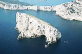
Piana island (107 m high) is high and conspicious, to 2 NM from NNW capo Caccia. It is part of the AMP C Caccia / I. Piana. The W area of the island and the whole area around a distance of about 300 m, are area "A", delimited by buoys. It is under absolute protection and all activities are prohibited including yachting.
2012/11/20
Update
Joëlle
L'île Piana (107 m de haut) est élevée et bien visible à 2M au NNW du cap Caccia. Elle fait partie de l'AMP C Caccia/I. Piana. La zone W de l'île et toute la zone autour, sur une distance d'environ 300 m, sont en zone "A", délimité par des bouées lumineuses. Elle est donc sous protection absolue et toute activité est interdite y compris le yachting.
2012/11/20
Update
Joëlle
L'isola Piana (107 m di alta) è alta e bene visibile a 2 MN a NNW di capo Caccia. Fa parte dell'Area naturale marina protetta Capo Caccia - Isola Piana. La parte verso ovest dell'isola e tutte le acque circostanti per una
distanza di ca 300 metri, sono zona "A", delimitata da boe di
segnalazione luminose, quindi area di protezione assoluta all'interno
del regolamento della AMP, ed è vietata qualunque attività compreso il
transito.
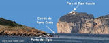
The park begins at Capo Galera to continue toward the gulf of Porto Conte that is protected by two promontories, Punta Giglio and Capo Caccia-Monte Timidone. The marine protected area embraces the stretch of sea to the north-west of Punta Cristallo.Almost all of the park consists ...
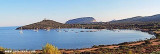
Porto Conte is a natural bay between Punta del Giglio and Caccia cape.Along E shore of the bay, on a projecting point, we see Porto Conte village, with the tower Nuova, which is backed by a turret with a light.You can anchor anywhere. The bay offers shelter from all winds. Mount ...
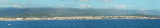
Rada di Alghero is entered between S, the town of Alghero and N, capo Galera.The E shore of this bay is low and sandy, and the W shore is hilly and rocky. An undulating coastal plain, partly under cultivation, lies immediately inland of the head of this bay.This bay is open to ...
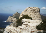
Overlooking the sea at about 280 m height, the tower of Pegna is a strategic point of view, part of the network of towers against enemy attacks, especially by Arab and French militias during the employment period of the Spanish / Aragonese.
On the W shore of Porto Conte is a cove with some ponttons reserved to yacht club. Visitors can dock only if there is berth.T. 079/946638 120 pl. (<10 m)Otherwise yachts can anchor in the bay.


 AMP C Caccia/I Piana
 Piana island (107 m high) is high and conspicious, to 2 NM from NNW capo Caccia.
 L'île Piana (107 m de haut) est élevée et bien visible à 2M au NNW du cap Caccia.
 L'isola Piana (107 m di alta) è alta e bene visibile a 2 MN a NNW di capo Caccia.
")
")
")