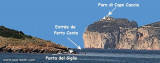
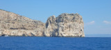
Facing the cliffs of Capo Caccia, to W, Foradada island (182 m high) is a fragment of coastline that was detached from the cliff a long time ago.
It is an imposing white limestone rock which owes its name to sardinian, to being "pierced" from left to right by a giant cave formed by the sea, forming visible part Foradada and partly submerged.
The island does not have landing points, you can reach it with the schedule and enter the cave on the west side even with big boats.
The island is part of the AMP Capo Caccia / I. Piana.
2012/11/20
Update
Joëlle
Isola Foradada (Sardegna)
2012-11-20
Update
Joëlle
En face des falaises de Capo Caccia, à l'W, l'île de Foradada (182 m de haut) est un fragment de côte qui s'est détaché de la falaise il y a très longtemps.
C'est un imposant rocher de calcaire blanchâtre qui doit son nom en sarde, au fait d'être «percé» de gauche à droite par une grotte géante formée par la mer, en partie émergée formant Foradada, et en partie submergée.
L'île ne dispose pas de points de débarquement, vous pouvez l'atteindre avec l'annexe et entrer dans la grotte sur le côté ouest même avec de gros bateaux.
L'île fait partie de l'AMP Capo Caccia/I. Piana.
2012/11/20
Update
Joëlle
Isola Foradada (Sardegna)
2012-11-20
Update
Joëlle
Di fronte alle falesie di Capo Caccia, all'W, l’isola Foradada (182 m di alta) è un frammento
di costa separatosi dall'isola madre in tempi antichissimi. È un imponente e suggestivo scoglio di biancheggiante calcare che deve
il suo nome in sardo per essere di fatto "forato" da parte a parte da
una gigantesca grotta scavata dal mare, da cui Foradada, ed in parte sommersa.
L'isola non presenta punti di approdo, è possibile arrivare solo in barca e accedere alla grotta sul lato ovest anche con barche di grandi dimensioni.
The park begins at Capo Galera to continue toward the gulf of Porto Conte that is protected by two promontories, Punta Giglio and Capo Caccia-Monte Timidone. The marine protected area embraces the stretch of sea to the north-west of Punta Cristallo.Almost all of the park consists ...
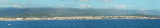
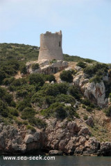
Porto Conte is a natural bay between Punta del Giglio and Caccia cape.Along E shore of the bay, on a projecting point, we see Porto Conte village, with the tower Nuova, which is backed by a turret with a light.You can anchor anywhere. The bay offers shelter from all winds. Mount ...
Rada di Alghero is entered between S, the town of Alghero and N, capo Galera.The E shore of this bay is low and sandy, and the W shore is hilly and rocky. An undulating coastal plain, partly under cultivation, lies immediately inland of the head of this bay.This bay is open to ...
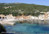
This small cove close, N of del Buru tower, offers a small beach of a few meters and a small dock to accommodate tour boats in the bay of Porto Conte and cave Nettuno.
We anchored between 6 and 14 m protected from the tip del Bollo.
Caccia cape is the S tip of a long, narrow and massive peninsula bordered by cliffs. It is characteristic by its dark color and its 169 m high cliff, dominated by a lighthouse beacon wich is visible up to 34 NM, white tower on white house with two floors.


 AMP C Caccia/I Piana
 Facing the cliffs of Capo Caccia, to W, Foradada island (182 m high) is a fragment of coastline that was detached from the cliff a long time ago.
")
 En face des falaises de Capo Caccia, à l'W, l'île de Foradada (182 m de haut) est un fragment de côte qui s'est détaché de la falaise il y a très longtemps.
")
 Di fronte alle falesie di Capo Caccia, all'W, l’isola Foradada (182 m di alta) è un frammento
di costa separatosi dall'isola madre in tempi antichissimi.
Di fronte alle falesie di Capo Caccia, all'W, l’isola Foradada (182 m di alta) è un frammento
di costa separatosi dall'isola madre in tempi antichissimi.")