Finocchiarola islands, previously connected at the Corsica, consists of
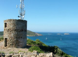
three islets which are surrounded by rocks. A ruined tower stands on the
E and largest islet. They are distinguished by their peculiar fauna
as well as rare endemic plants. They are home to several species of
birds including the famous Audouin's Gull.
To preserve this
precious refuge a 380ha nature reserve was established in 1987. the
chenal between the last island and the land, is closed by a big wreck,
of around one hundred meters, shipwreck which emerge only a few sheets.
Only small boats can pass by surveying, by good weather in the mazes.
2012/05/1
Update
Jojo
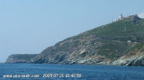
Cardinale Est au large de l'Ile Finacchiarola
2005-07-18
Bearing:270°
2005:07:18 19:42:09
2012-05-01
Update
Jojo
Autrefois rattachées à la Corse, les îles Finocchiarola ou Finacchiarola (en corse Finuchjarola) forment un archipel inhabité de la mer Tyrrhénienne. Elles se trouvent toutes proches de la côte nord-est du Cap corse, sur la commune Rogliano, entre la baie de Tamarone (au sud) et celle de Santa Maria (au nord), et sont constituées de trois îlots désertiques entourés de rochers :
A Terra, le plus proche de la côte (200 m) ;
Mezzana, l'îlot central ;
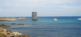
Finocchiarola, le plus grand, le plus haut et le plus au large des îlots (500 m) ; il culmine à 27 m au niveau de la tour ruinée.
Les deux îlots les plus au larges sont la propriété du Conservatoire du littoral aujourd'hui, et le troisième entre dans sa zone d'intervention.
La passe entre la dernière île et la terre, est barrée par une grosse épave, d'une centaine de mètres, bateau naufragé dont émergent seulement quelques tôles. Seule les petits bateaux peuvent passer "à vue", par beau temps, dans ces dédales.
Gisement d'amphores romaines, aux Ilots de Finacchiarola (ou Finocchiarola).
2012/05/1
Update
Jojo
2012-05-01
Update
Jojo
Impossiblilité de passer entre les ilots. Attention aux nombreux plongeurs et chasseurs sous marins.
2005-07-18
Bearing:270°
2005:07:18 19:42:15
2012-05-01
Update
Jojo
En 1594, une tour littorale fut construite au point culminant du plus grand îlot.
Elle était destinée à la défense du Cap corse sous l'occupation génoise et est
aujourd'hui en état de ruine.
2005:07:18 19:48:55
2012-05-01
Update
Jojo
C'est la réserve naturelle la plus petite de Corse, elle a été créee
pour protéger la colonie de goéland d'Audouin, espèce endémique de
Méditerranée.
2021/02/9
Update
Jojo
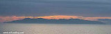
Levé de soleil sur nos îles Finocchiarola
2021-02-10
Update
azerty
Share your comments or photos on "Iles Finocchiarola"
Capo Sagro is located at 11 NM. S Finocchiarola islands. He has a signal station and a semaphore rises N of it. Mount Merizatodio, 778 m high, is 1.5 MN to W Cape and dominates the immediate area.
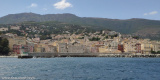
The village of Erbalunga, situated 1.5 miles SSW of Capo Sagro, stands on the S ...
Capraia is one of the seven islands of the Tuscan Archipelago, on the road between Cape Corsica and Elba. It is an island of 335 inhabitants (the Capraiesi) of the Province of Livorno. It lies 64 km from Livorno, 37 km from Gorgona and 31 km from Corsica. Its area is 19 km2. It has ...
Located between Marines de Sisco and Erbalunga, this point is well known to divers. Cape Sagro is an anchorage where the ancient Roman fleet landed the goods for this part of Cap Corse.
This site is of outstanding beauty and it is not unusual to see diving teams of experienced ...
Pointe de la Coscia, located 1 mile S of Sommet Tamarone, is the S entrance point of Baie de Tamarone. This bay is 0.7 mile wide and affords shelter from W winds. Surrounded by a beautiful sandy beach is a pleasant good weather anchorage.
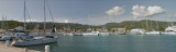
Macinaggio, a village, is situated in a bay which is entered S of Pointe de la Coscia. It is fronted by a small harbor which is protected by two jetties and has extensive facilities for small craft and yachts. The harbour is not sheltered from wind. T. 04 95 35 42 57 F. 04 95 35 ...


 Narural reserve of Finocchiarola.
 Finocchiarola islands, previously connected at the Corsica, consists of
three islets which are surrounded by rocks. A ruined tower stands on the
E and largest islet.
Finocchiarola islands, previously connected at the Corsica, consists of
three islets which are surrounded by rocks. A ruined tower stands on the
E and largest islet. Cardinale Est au large de l'Ile Finacchiarola
2005-07-18
Bearing:270°
Cardinale Est au large de l'Ile Finacchiarola
2005-07-18
Bearing:270° Autrefois rattachées à la Corse, les îles Finocchiarola ou Finacchiarola (en corse Finuchjarola) forment un archipel inhabité de la mer Tyrrhénienne. Elles se trouvent toutes proches de la côte nord-est du Cap corse, sur la commune Rogliano, entre la baie de Tamarone (au sud) et celle de Santa Maria (au nord), et sont constituées de trois îlots désertiques entourés de rochers :
 Impossiblilité de passer entre les ilots. Attention aux nombreux plongeurs et chasseurs sous marins.
2005-07-18
Bearing:270°
Impossiblilité de passer entre les ilots. Attention aux nombreux plongeurs et chasseurs sous marins.
2005-07-18
Bearing:270° En 1594, une tour littorale fut construite au point culminant du plus grand îlot.
Elle était destinée à la défense du Cap corse sous l'occupation génoise et est
aujourd'hui en état de ruine.
En 1594, une tour littorale fut construite au point culminant du plus grand îlot.
Elle était destinée à la défense du Cap corse sous l'occupation génoise et est
aujourd'hui en état de ruine. Levé de soleil sur nos îles Finocchiarola