Hasle

Hasle

To precisely geolocate this site. Update if necessary.

Localisation

Hasle
LatitudeLongitude
DMS------
DM------
DD------

Characteristics

Port
Water
Fuel
First aid
Shipyard
Grocery

Description

Small port protected by a breakwater.
2011/07/30
Update
splattter
Petit port protégé par une digue.
2011/07/30
Update
splattter
Ebook

Baltic sea

  • 84 sites
  • 71 photos
  • publication date: 11 Jul 2023
  • .pdf file size: 70 Mb
Share your comments or photos on "Hasle"

Sites around Hasle

Flying distances - Direct line

Dueodde

17nm
132°
Dueodde
BornholmDueodde fyr blev opført i årene 1960-62 og blev taget i anvendelse onsdag den 15. august 1962 kl. 19:22. Tårnet er opført i jernbeton på et fundament af 14 m. lange jernbetonpæle hvoraf der skulle 19 stykker til, for at sikre et godt fæste i den sandede grund. ...
24 Aug 11
atb06

Ystad Marina

33nm
295°
Port protected by a breakwater.
29 Jul 11
evilgusgus

Świnoujście Marina

78nm
191°
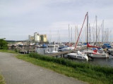
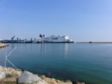
The marina is a modern yacht harbour with 200 berths and comfortable equipment.  Access You must expect currents in the mouth of the Swine, which may even put you off course when the wind blows from the west.
26 Jun 14

Port Świnoujście

78nm
191°
For the approach use the navigation channel:- 32Nm long
- width 180m
- depth 14mThe port can accomodate ships of up to 270m long.The port is ice free.
27 Jun 14
DD06

Trelleborg

54nm
281°
Port protected by a breakwater.
29 Jul 11
iansilv