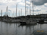
The Gulf of Bothnia (Finnish: Pohjanlahti; Swedish: Bottniska viken, i.e. Bottenviken + Bottenhavet) is the northernmost arm of the Baltic Sea.
2010/10/1
Update
Toto 7
Island
2012/07/4
Update
Le golfe de Botnie (en suédois : Bottniska viken, en finnois : Pohjanlahti) est situé dans la mer Baltique, entre les côtes finlandaises à l'est et les côtes suédoises à l'ouest. Au sud du golfe se situent l'archipel d'Åland (nom suédois) ou Ahvenanmaa (nom finnois), qui sont les principales îles du golfe. Elles sont de souveraineté finlandaise, mais sont largement autonomes et la population y parle majoritairement suédois.
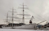
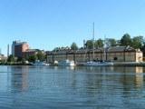
Naval museum where you can see the tall ship "Suomen Joutsen". She was built in 1902 by Chantiers de Penhoët in St. Nazaire, France, as Laënnec. In 1930 she became a school ship for the Finnish Navy.


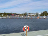
 The Gulf of Bothnia (Finnish: Pohjanlahti; Swedish: Bottniska viken, i.e. Bottenviken + Bottenhavet) is the northernmost arm of the Baltic Sea.
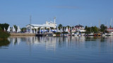
 Le golfe de Botnie (en suédois : Bottniska viken, en finnois : Pohjanlahti) est situé dans la mer Baltique, entre les côtes finlandaises à l'est et les côtes suédoises à l'ouest. Au sud du golfe se situent l'archipel d'Åland (nom suédois) ou Ahvenanmaa (nom finnois), qui sont les principales