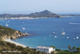
Cagliari Gulf is entered between Capo Carbonara and Capo di Pula. The two sides of the gulf are mountainous, but a long stretch of sandy shore lies at the head and is broken only by Capo Sant’Elia.
Several extensive saltwater lagoons and areas of marshes lie behind the sandy shore.
The prevailing winds in the gulf are from the W and ENE, and these may increase suddenly to violent storm which can last for 3 days. The W winds gain in velocity as the barometer falls, while the ENE winds increase as the barometer rises.
2012/10/16
Update
Joëlle
Le golfe de Cagliari se trouve entre le cap Carbonara et le cap de Pula. Les deux côtés du golfe sont montagneux, mais une longue plage de sable étroite borde la côte. Elle est coupée seulement par le Cap Sant'Elia.
Plusieurs vastes lagunes d'eau salée et des zones de marais se cachent derrière la plage de sable.
Les vents dominants dans le golfe sont d'W et d'ENE, Ils peuvent augmenter brusquement et provoquer de violentes tempêtes qui peuvent durer 3 jours. Le vent d'W gagne en vitesse lorsque le baromètre chute, tandis que le vent d'ENE augmente avec le baromètre.
2012/10/16
Update
Joëlle
Il Golfo di Cagliari si trova tra il capo Carbonara e il Capo di Pula. I due lati del golfo sono montagnose, ma una lunga stretta spiaggia di sabbia si affacciano sul litorale. Si è rotto solo dal Capo Sant'Elia.
Diversi lagune di acqua salata e Aree di paludisi nascoderano dietro la spiaggia di sabbia.
I venti dominanti nel Golfo sono W e ENE, possono aumentare improvvisamente e causare forti tempeste che possono durare tre giorni. La a velocità del vento W aumenta quando il barometro è in calo, mentre il vento ENE aumenta con il barometro.
Quartu gulf lies between Foxi tower and S. Elia cape, in the Cagliari Gulf.It is not recommended to anchor in the Quartu bay.Ancorage is also prohibited in a strip between the bearings to 314 ° of Mezza Spiaggia tower and 316 ° to the S. Elia E end cape and extending to 7 NM of shore.
Carbonara gulf is located between Carbonara cape and Boi cape, in the Cagliari gulf, on its E side.Depending on the wind,we anchor on the W or E side of the bay. This large bay, rock and sand bottom, is very pretty and very crowded in summer. NW of Carbonara cape, Carbonara Bay ...
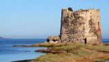
The tower, built on the homonymous beach, on the coast of Quartu, was built by the Spaniards in 1578.
Its purpose was to monitor landings of the Saracens on theQuartu coast . It was guarded by two soldiers with arms that connected the W with the Carcangiolas tower and ...
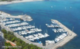
The Capitana marina, or Porto Amando, is located SE side Cagliari gulf and to 6,5 NM E S. Elia cape. Tel: (+39) 070805460Fax: (+39) 070805420Mail: marinadicapitana@tiscali.itWebsite: WWW.MARINADICAPITANA.IT 480 b. (<27 m)
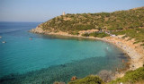
Cala Regina is in Terramata locality, in the town of Quartu Sant'Elena, W capo Boi.
Cala Regina has a background of rocks and gravel near the beach, it is lined with rocks. The cove is dominated by a Spanish watchtower perched on a promontory overlooking the sea, covered with ...
Piccola Marina is located W town, behind Sant'Elia promontory, in the resort area. It is protected by a breakwater 300 m long breakwater ending in a large square. Inside there are some floating piers. 350 b. incl. 35 visit.(<18 m) T. 070-6051940Mail: motomarsarda@tiscali.it


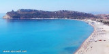


 Cagliari Gulf is entered between Capo Carbonara and Capo di Pula. The two sides of the gulf are mountainous, but a long stretch of sandy shore lies at the head and is broken only by Capo Sant’Elia.
 Le golfe de Cagliari se trouve entre le cap Carbonara et le cap de Pula. Les deux côtés du golfe sont montagneux, mais une longue plage de sable étroite borde la côte. Elle est coupée seulement par le Cap Sant'Elia.
 Il Golfo di Cagliari si trova tra il capo Carbonara e il Capo di Pula. I due lati del golfo sono montagnose, ma una lunga stretta spiaggia di sabbia si affacciano sul litorale. Si è rotto solo dal Capo Sant'Elia.
")