Quartu gulf lies between Foxi tower and S. Elia cape, in the Cagliari Gulf.It is not recommended to anchor in the Quartu bay.Ancorage is also prohibited in a strip between the bearings to 314 ° of Mezza Spiaggia tower and 316 ° to the S. Elia E end cape and extending to 7 NM of shore.
Carbonara gulf is located between Carbonara cape and Boi cape, in the Cagliari gulf, on its E side.Depending on the wind,we anchor on the W or E side of the bay. This large bay, rock and sand bottom, is very pretty and very crowded in summer. NW of Carbonara cape, Carbonara Bay ...
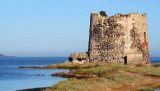
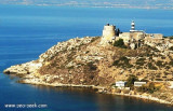
The tower, built on the homonymous beach, on the coast of Quartu, was built by the Spaniards in 1578.
Its purpose was to monitor landings of the Saracens on theQuartu coast . It was guarded by two soldiers with arms that connected the W with the Carcangiolas tower and ...
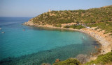
Cala Regina is in Terramata locality, in the town of Quartu Sant'Elena, W capo Boi.
Cala Regina has a background of rocks and gravel near the beach, it is lined with rocks. The cove is dominated by a Spanish watchtower perched on a promontory overlooking the sea, covered with ...
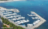
Piccola Marina is located W town, behind Sant'Elia promontory, in the resort area. It is protected by a breakwater 300 m long breakwater ending in a large square. Inside there are some floating piers. 350 b. incl. 35 visit.(<18 m) T. 070-6051940Mail: motomarsarda@tiscali.it
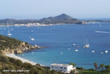
S. Elia cape is a pronotory with remarkable white patches on the W tip.At E end tip, is Del Poetto tower, that overlooks Piccola marina. S. Elia tower (1282) is located between the lighthouse and Del Poetto tower. It is partly in ruins and is 139 m above sea level. Finally on a ...


 Marina di Capitana
 canal 74
 070805460


")
")
")
")
 The Capitana marina, or Porto Amando, is located SE side Cagliari gulf and to 6,5 NM E S. Elia cape.
 La marina di Capitana (ou Porto Amando) est située sur la côte SE du golfe de Cagliari et à 6,5 M de l'E du cap S. Elia.
 La Marina di Capitana è situata lungo la costa SE del Golfo di Cagliari, a 6,5 NM E da Capo S. Elia.