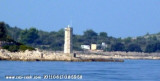
The small village of Drvenik is at the bottom of a bay which is divided into two parts, with the port while E. A marina, the marina Zirone is under construction. It is located NW of the village. The purpose is to anchor near the village by 8 m. Good protection. The marina offers under construction to house 120 boats. The services are not yet operational in 2011. Tel: 385 021 362 722
2011/07/7
Update
Jojo
Le petit village de Drvenik se trouve au fond d'une baie qui se divise en 2 parties, avec le port tout à l'E. Une marina, la marina Zirona, est en cours de construction. Elle est située au NW du village.
L'usage est de mouiller près du village par 8 m. Bonne protection.
La marina en construction propose d'abriter 120 bateaux. Les services ne sont pas encore opérationnels en 2011.
Ciovo is an island in the center of the Dalmatian archipelago. This is an area of 28.8 acres (15.3 km length, width of 3.5 km). It culminates at 218 m (Mount Rudin). O. Ciovo forms the SW side of the entrance and inner part of Kastelanski Zaliv. At East side, Ciovo is 2km from ...
Island accessible only by sea. It is long about 3 m long by 2 m wide. It is 2 M NW of otok Solta.Its area is 12.07 km ² and its highest point is 178 m.It is separated from the mainland by Drvenicki Kanal. The coast of this beautiful island has remained intact and is made of many ...
Otok Zirje
is the farthest and the largest island in the Sibenik archipelago. It is long of 6,5 NM (NW/SE) and 1,4 NM wide. The main village, Zirje, is located in the middle of the island. A small port, luka Muna, on the coast N of Zirje, home to the ferry that connects the ...
Otok Svetac (Andrija), 305m high, lies 13 miles ESE of Otocic Jabuka and is generally steep-to. The coast of the island is rocky and reddish in color on the NW side. Its SW end is fronted by a few rocks. Hrid Kamik, a dark and jagged above-water rock, lies 0.7 mile W of the SW extremity ...
Very close to Drvenik Veli (1 M), Drvenik Mali, the W Drvenik Veli, made 2 M in E and W 1 M to its widest point. The coast is cut and the sea around the island is shallow. Its highest point is 79 meters high. There is a small port on the NE coast of the island. The ...


")
")
 The small village of Drvenik is at the bottom of a bay which is divided into two parts, with the port while E. A marina, the marina Zirone is under construction. It is located NW of the village.
 Le petit village de Drvenik se trouve au fond d'une baie qui se divise en 2 parties, avec le port tout à l'E. Une marina, la marina Zirona, est en cours de construction. Elle est située au NW du village.