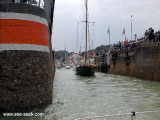
Dieppe lies in a valley at the mouth of the Riviere Arques. The port, which is primarily a cross-channel ferry terminal, also has facilities for cargo vessels, fishing boats, and recreational craft. The harbor consists of Avant-port, Arriere-port, Bassin du Canada, Bassin de Paris, and Bassin Duquesne.
The town's many bars and restaurants have made it renowned for its cuisine, with famed local dishes and delicacies such as Sole Dieppoise and Marmite Dieppoise.
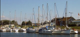
3 locations for yachts :
Bassin Ango (400 berths)
Bassin Duquesne (70 berths)
Bassin de Paris (70 berths).
Comply with port traffic signals and watch on VHF 12. Report to VHF channel 9 before entering the marina. Speed limited to 3 knots.
2012/05/5
Update
Geof
Cette cité portuaire compte 4 ports au coeur de la ville et possède également un patrimoine riche. Ses nombreux bars et restaurants en font une ville gastronomique connue pour sa tradition culinaire notamment avec quelques recettes typiques : la sole dieppoise, la marmite dieppoise La plaisance occupe trois bassins :
le bassin Ango (400 places)
le bassin Duquesne (70 places)
le bassin de Paris (70 places).
Port parmi les plus chers de toute la Manche.
Conformez-vous aux signaux portuaires et veillez sur le canal VHF 12. Annoncez-vous sur canal VHF 9 avant d’entrer dans la marina. Vitesse limitée à 3 noeuds.
Madame,Monsieur, Vendredi, le 26 juillet dernier, mes amis et moi-même avons visité Dieppe.Lorsque nous étions garés sur le parking près de l'église en face de votre sémaphore, un jeune homme de 23 ans, s'est rejoint à nous. Il conduisait une Peugeot. Il disait qu'il ...
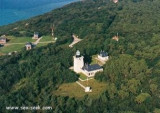
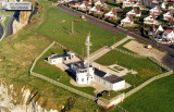
Pointe d’Ailly, located 5 miles ENE of Pointe de Scotteville, is fronted by dark, vertical cliffs and has a rounded summit. Pointe d’Ailly Light is a prominent square tower, 24m high, standing on the point.
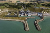
Penly Nuclear Power Station stands near to the shore, 5.4 miles NE of Dieppe. It is fronted by a prohibited area, which extends up to 0.8 mile seaward and is marked by lighted buoys. A narrow winding channel leads between short breakwaters to the power station. A prominent radio ...
Port ayant la particularité d'être, à la fois, un port de plaisance et un port de pêche côtier. Il possède 600 places de port à flot, bien protégés contre les intempéries. Tous ses équipements (pontons, électricité, bloc sanitaire en construction ) ont été remis ...
Le Treport, situated at the mouth of La Bresle, is a small port used by commercial vessels, fishing boats, and recreational craft. It consists of Avant-port, which dries, and two wet basins. Le Treport stands on the SW side of the harbor and the smaller town of Mers-les-Bains ...
Paluel Nuclear Power Statio, with four conspicuous towers 72m high, is situated 6.5 miles ENE of Saint-Pierre-en-Port. A pylon and a water tower, both prominent, stand close SW and about 1.3 miles S, respectively, of the power station. Two short breakwaters protect the entrance ...


 Canal 9


 Dieppe lies in a valley at the mouth of the Riviere Arques. The port, which is primarily a cross-channel ferry terminal, also has facilities for cargo vessels, fishing boats, and recreational craft.
 Cette cité portuaire compte 4 ports au coeur de la ville et possède également un patrimoine riche. Ses nombreux bars et restaurants en font une ville gastronomique connue pour sa tradition culinaire notamment avec quelques recettes typiques : la sole dieppoise, la marmite dieppoise