Le Tréport

Le Tréport

To precisely geolocate this site. Update if necessary.

Localisation

Le Tréport
LatitudeLongitude
DMS------
DM------
DD------

Characteristics

Port
VHF Canal 12
Water
Electricity
Fuel
Shipyard
Shower
WC
Restaurant

Description

Le Tréport
2010-05-31
Update
Anonymous
Ebook

Manche - English Channel

  • 240 sites
  • 186 photos
  • publication date: 7 Jul 2023
  • .pdf file size: 229 Mb
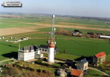
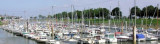
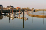
Le Treport, situated at the mouth of La Bresle, is a small port used by commercial vessels, fishing boats, and recreational craft. It consists of  Avant-port, which dries, and two wet basins.
Le Treport stands on the SW side of the harbor and the smaller town of Mers-les-Bains stands on the NE side.

The tides rise 9.4m at springs and 7.5m at neaps. Strong onshore winds cause a heavy scend in the outer harbor.

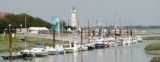
Several quays border Avant-port and dry 4 to 5m, with a bottom of soft mud. Part of Quai Bellot, on the N side, is used by recreational craft.
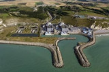
Port du Peche (Fishing Port) et de Plaisance is entered from the SE end of Avant-port through a lock, 28m long and 9.5m wide. It is used by fishing vessels and recreational craft.
Port du Commerce is entered from the NE end of Avant-port through a dock gate, which is 19m wide and has a depth of 2m on the sill.

2012/05/5
Update
Geof
Le Tréport
2012-05-05
Update
Geof
Le port départemental du Tréport a été construit sur l'embouchure de la Bresle, rivière qui marque historiquement la limite entre la Normandie et la Picardie. Il est situé dans le bassin de pêche. Capacité d’accueil :
- Dans le bassin de pêche 110 mouillages
- 15 mouillages dans le bassin en amont du pont mobile
- Dans l’avant port : 100 mouillages marnant.

Mise à disposition : pontons ; eau ; électricité ; sanitaires Entrée et sortie : 4h avant et après la pleine mer par le sas : 02 35 50 63 06 ou
VHF : canal 12
2019/06/6
Update
Geof
Share your comments or photos on "Le Tréport"

Sites around Le Tréport

Flying distances - Direct line

Sémaphore et Phare de Ault

3.8nm
46°
Histoire
C'est au début du XIXème siècle que furent construits les sémaphores de Cayeux et Hautebut, avec pour rôle la surveillance des approches de la baie de Somme.
Durant la deuxième guerre mondiale, le personnel du sémaphore de Cayeux est renforcé par une vingtaine ...
5 May 12
Geof

Centrale Electrique de Penly

8.3nm
233°
Penly Nuclear Power Station stands near to the shore, 5.4 miles NE of Dieppe. It is fronted by a prohibited area, which extends up to 0.8 mile seaward and is marked by lighted buoys. A narrow winding channel leads between short breakwaters to the power station.
A prominent radio ...
5 May 12
Geof

Phare de Cayeux

9.4nm
32°
Phare automatisé. Éclat rouge toutes les 5s.
5 May 12
Geof

Le Hourdel

11nm
37°
Le Hourdel, a small harbor, lies between the S side of Pointe du Hourdel and a detached breakwater, 300m long. The basin dries and is used by recreational craft and fishing boats.
Le Hourdel Light is shown from a prominent tower, 18m high, standing on Pointe du Hourdel.
5 May 12
Geof

Saint Valéry sur Somme

12nm
54°
Saint-Valery-sur-Somme, a small harbor, is situated on the S shore of the bay, 2.5 miles ESE of Pointe du Hourdel. It is used by small commercial vessels and recreational craft.
The entrance channel leading to the harbor dries 5.8m and is marked by buoys and beacons. The fairway ...
5 May 12
Geof

Le Crotoy

13nm
45°
Port disposant de 120 places pour petits bateaux (<9m).
Le port a comme principales activités la pêche en mer, la pêche à pied pour les coques et la culture récente des moules de bouchot.
7 Oct 15
Donald_Duck