Paluel Nuclear Power Statio, with four conspicuous towers 72m high, is situated 6.5 miles ENE of Saint-Pierre-en-Port. A pylon and a water tower, both prominent, stand close SW and about 1.3 miles S, respectively, of the power station. Two short breakwaters protect the entrance of a channel leading to the power station. A prohibited area, marked by a lighted buoy, surrounds the cooling water pipelines serving the power station.
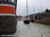
Port ayant la particularité d'être, à la fois, un port de plaisance et un port de pêche côtier. Il possède 600 places de port à flot, bien protégés contre les intempéries. Tous ses équipements (pontons, électricité, bloc sanitaire en construction ) ont été remis ...
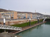
Votre bateau est
mis à l’eau à votre demande et positionné sur le ponton d’accueil qui
permet une sortie en mer directe et immédiate. L’enlèvement du bateau du
rack de stockage se fait à l’aide d’un chariot élévateur. Il est
ensuite déposé sur un ascenseur ...
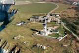
Histoire En 1902, la mise en service du phare de la jetée Sud entraîne la fermeture de celui de la vierge. Le ministère de la marine décide alors d'y transférer le sémaphore. En effet, bien que jouxtant l'ancien et culminant à 104 mètre, il offre une meilleur base d'observation. En ...
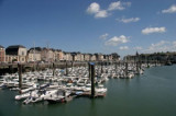
Fecamp, lying in a valley close S of Point Fagnet, is a small port with facilities for commercial vessels, fishing boats, and pleasure craft. The harbor consists of Avant-port, Arriere port, Bassin de Mi-Maree, and two non-tidal basins.With winds from the W through N to NE, visibility ...
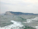
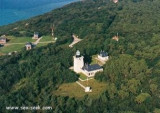
Pointe d’Ailly, located 5 miles ENE of Pointe de Scotteville, is fronted by dark, vertical cliffs and has a rounded summit. Pointe d’Ailly Light is a prominent square tower, 24m high, standing on the point.
Dieppe lies in a valley at the mouth of the Riviere Arques. The port, which is primarily a cross-channel ferry terminal, also has facilities for cargo vessels, fishing boats, and recreational craft. The harbor consists of Avant-port, Arriere-port, Bassin du Canada, Bassin de Paris, ...