DANGER Haut-fond Montjol

DANGER Haut-fond Montjol

To precisely geolocate this site. Update if necessary.

Localisation

DANGER Haut-fond Montjol
LatitudeLongitude
DMS------
DM------
DD------

Characteristics

Description

Attention à ce haut-fond mal signalé
2017/07/10
Update
Ludo66
Ebook

Espagne Est - East Spain

  • 235 sites
  • 414 photos
  • publication date: 7 Jul 2023
  • .pdf file size: 180 Mb
DANGER Haut-fond Montjol
Cala Motjol
2017-07-10
Update
Anonymous
Share your comments or photos on "DANGER Haut-fond Montjol"

Sites around DANGER Haut-fond Montjol

Flying distances - Direct line

Bahia de Rosas

4.2nm
272°
Rosas bay lies between Rio Muga and La Bateria (or Blancals) point.
8 Jul 12
Jojo

Cala Rustella (Roses)

0.4nm
244°
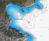
Cala Rustella is SE cala Monjoy. It is one of numerous natural coves that we found under Norfeo cape, and it is beautiful.Anchorage under sand and rocks depth.
9 Jul 12
Jojo

Cala Monjoy (Roses)

0.4nm
305°
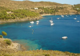
A very large cove well protected from the North but still a little roller, easy anchorage or in East Cove (Cala Pelosa), or before the village's beach holiday-dive very busy because accessible by road.
9 Jul 12
Jojo

Cala Murtra (Roses)

0.6nm
227°
Anchorage by good weather.The beach, more easily accessible by boat is fairly deserted.
It is 150 m long and 10 m wide. This is a nudist beach.
9 Jul 12
Jojo

Cala de Jonculls (Roses)

0.9nm
65°
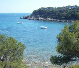
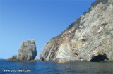
Just N Norfeo cape, Jonculls (Joncols) cove is deep, and the bottom suddenly rises to 5m near the small beach.
The scenery was beautiful, in the immense cliffs. It is somewhat sheltered from the swell.
It is possible take a buoy for free if you are at lunch in one ...
3 May 14
Atb

Cabo Norfeo

1.2nm
105°
Cabo Norfeo is the E extremity of a peninsula dominated by a ruined tower.
8 Jul 12
Jojo