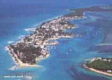
Elliott Key is the northernmost of the true Florida Keys (those 'keys' which are ancient coral reefs lifted above the present sea level), and the largest key north of Key Largo. It is located entirely within Biscayne National Park. It is bordered by the Atlantic Ocean to ...
The first underwater park in the U.S., John Pennekamp Coral Reef State Park encompasses approximately 70 nautical square miles. It is the coral reefs and their associated marine life that bring most visitors to the park. Many enjoy the view of the reef from a glass-bottom ...
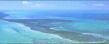
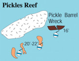
Pickles Reef is located about five and a half nautical miles off the southern part of Key Largo. Visibility is usually 40 to 70 feet, and current isn't ever really too strong. Pickles Reef has no marker or mooring buoys. The depth of the water here ranges from 10' to 25'. It's located ...
Key Largo Dry Rocks lies within the boundaries of the previous Key Largo National Marine Sanctuary.Key Largo Dry Rocks is located seaward of White Banks and extends to an approximate depth of 30 feet. Dry Rocks SPA covers an area of approximately 0.05nm2, or about 16ha, and ...