L'île doit son nom soit au pirate Arthur Catt, soit à sa forme qui
ressemble à un félin assis. Néanmoins, durant de nombreuses années,
l'île fut appelée San Salvador, et ne fut renommée qu'en 1926.
L'île possède une seule et unique route, une plage de sable rose de 12 km de long et le point culminant des Bahamas: le Mont Alvernia (63 mètres).
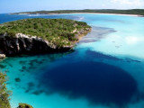
Dean's Blue Hole is one of the most famous diving sites in the world. It is located on the Out Islands of Bahamas, just north of Clarence Town, the biggest settlement of Long Island.It is the world's deepest blue hole and it is found next to a beach. It is only 25-30 meters in circumference ...
The Straits of Florida, Florida Straits, or Strait of Havami is a strait located south-southeast of the North American mainlad, generally accepted to be between the Gulf of Mexico and the Atlantic Ocean, and between the Florida Keys and Cuba. The strait carries ...
Long Key was called Cayo Vivora (Rattlesnake Key) by early Spanish explorers, a reference to the shape of the island, which resembles a snake with its jaws open, rather than to its denizens. In the early 20th century, Long Key was the site of a luxurious fishing resort that ...


")