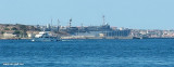
Isola La Maddalena (Arcipelago della Maddalena)
3.4nm
348°
It is connected by a bridge to Caprera island where are the house and the tomb of Garibaldi. ...
26 Nov 12
Joëlle
| Latitude | Longitude | |
| DMS | --- | --- |
| DM | --- | --- |
| DD | --- | --- |

") NE Sardaigne
NE SardaigneEbook | Sardegna North East
|

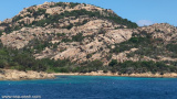
 Le cap d'Orso est escarpé et dénudé. Son extrémité NE est très basse, elle porte un phare. Il fut activé par la Marine Militaire en 1924.
 Il se trouve au bord de l'eau, en dessous de la fortification de Cap d'Orso. Il a une portée de 10 Milles.
Le cap est dominé à 0,5 M au SW par la colline d'Orso, haute de 130 m. Cap d'Orso è ripida e nuda. La sua estremità NE è molto bassa, ha un faro. E 'stato attivato dalla Marina Militare nel 1924.
Ebook | Sardegna
|