Corno islet, 16 m high, lies 0,8 MN W of the cape and is steep-to.
2012-10-27
Update
Joëlle
Capo Sandalo (134m), located W coast of San Pedro island, massive and abrupt, is dominated by a lighthouse, 30m high white tower on a white house with a floor built in 1864.
It is fronted by a small island, called Il Corno.
It 's the most westerly lighthouse in Italy, the last reassuring light that ships meet in the route from south to Gibraltar. His lantern moves in the darkness of the night up to 28 miles.
2012/10/28
Update
Joëlle
Le cap Sandalo (134 m), situé sur la côte W de l'île San Pedro, massif et abrupt, est dominé par un phare, tour blanche haute de 30m sur une maison blanche à un étage, construit en 1864.
Le cap est débordé par un îlot appelé Il Corno.
C'est le phare le plus à l'W d'Italie, la dernière lumière rassurante que les navires rencontrent sur la route du sud vers Gibraltar. Sa lanterne se déplace dans l'obscurité de la nuit jusqu'à 28 miles.
2012/10/28
Update
Joëlle
Il capo Sandalo (134 m), è costa W dell'isola San pedro, massiccio e brusco, è dominato da uno faro, torre alta di 30 m bianco su una casa bianca con un piano, costruito nel 1864.
Il capo è preceduto da una piccola isola, chiamata Il Corno.
E' il faro più occidentale d’Italia, l’ultima rassicurante luce che le navi
incontrano nella rotta da sud verso Gibilterra. La sua lanterna solca il buio della notte fino a 28 miglia.
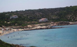
Spalmatore Grande Baia is between Spalmatore di Fuori Point and Dei Cannoni Point. In the bay, at Starboard on entering, is a small cove called Caletta. Anchor in 3 to 10 m.
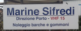
Marina Sifredi, SW Sardinia, is on the E side of Isola di San Pietro, close to the only town on the island, Caloforte. Marina Sifredi has two marinas located respectively in the North and South of Caloforte harbour. Sifredi marina is in the N and S area of Caloforte harbour. Mamma ...
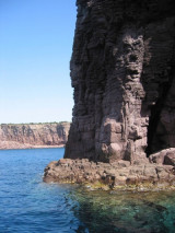
Mezzaluna gulf is between Grossa point and Buemarino point, W of Genia. This beautiful gulf is surrounded by red rocks 30/35 m high. In the fissures of the rocks we can see the entrance of the caves.You can anchor in 12 to 14 m in the middle of the bay.
At about 600 m from the shore, it must be very careful at a small shoal barely touches the water and that should keep well offshore. The seabed in this area are low, around 5 m, and fell rapidly to about 25 m.
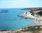
Even the small island of Genia, which emerges near the center of ...
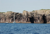
Punta delle Colonne, S end of S. Pietro island. It is is the most southern tip of the island, and it marks the beginning of the rocky part of the island. In fact, although not higher than 20 meters, the walls of rocks fall into the sea with an impressive verticality.


")
")
")
") Corno islet, 16 m high, lies 0,8 MN W of the cape and is steep-to.
Corno islet, 16 m high, lies 0,8 MN W of the cape and is steep-to. Capo Sandalo (134m), located W coast of San Pedro island, massive and abrupt, is dominated by a lighthouse, 30m high white tower on a white house with a floor built in 1864.
 Le cap Sandalo (134 m), situé sur la côte W de l'île San Pedro, massif et abrupt, est dominé par un phare, tour blanche haute de 30m sur une maison blanche à un étage, construit en 1864.
 Il capo Sandalo (134 m), è costa W dell'isola San pedro, massiccio e brusco, è dominato da uno faro, torre alta di 30 m bianco su una casa bianca con un piano, costruito nel 1864.