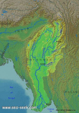

Gulf of Martaban (Burma)
60nm
92°
The Sittang River flows into the head of the gulf, about 75 miles N of the entrance. The Rangoon River and the Moulmein River enter the sea on the ...
21 Nov 11
Jojo
| Latitude | Longitude | |
| DMS | --- | --- |
| DM | --- | --- |
| DD | --- | --- |

 From Cape Negrais, the coast of the Irrawaddy Delta is low along its entire length between the Bassein River and the Sittang River.
 The only high coastal ground lies on the W side of the mouth of the Bassein River; here the S extremity of the Arakan Yoma Range terminates in the vicinity of Maw Dengi.
Between the Bassein River and the China Bakir River there are no landmarks and the navigational aids are few in number.
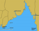
Depths—Limitations.—Between positions S of Purian Point and Baragua Point, the 20m curve lies about 10 to 20 miles offshore. The 10m curve roughly parallels the 20m curves at distances of about 2 to 8 miles within the latter curve.
Shoal depths of 5.5m and less lie between the 11m curve and the shore.
The 20m curves lies about 18 miles SE and 21 miles E of Baragua Point and then extends E to the vicinity of Kalegauk Island, and approximates the outer limits of the Gulf of Martaban.
The 10m curve to the SE and E of Baragua Point lies only about 1 to 2 miles within the 20m curve, but to the ENE it lies between 8 and 30 miles offshore.
A shoal, with a depth of 9.1m, was reported to lie about 46 miles S of Elephant Point.
Caution.—Vessels should not approach within a distance of 3 miles of the coast in the vicinity of Cape Negrais. A fringing reef and off-lying rocks make caution advisable even outside this distance.
The shallow bank, which fronts the delta shore between Purian Point and Baragua Point, should not be shoaled to depths of less than 18.3m.
Ebook | Andaman sea
|