Cala Spalmatore (Maddalena)

Cala Spalmatore (Maddalena)

To precisely geolocate this site. Update if necessary.

Localisation

Characteristics

Mooring buoy 15 euro/day
Sand
Water Fontanella
Phone
Parking
Market
Restaurant small bar on the beach in summer
Beach
Sand
Rock
Parasol only in summer
Natural Park
Anchorage prohibited

Description

S of Massimo Port, cala Spalmatore is a natural bay which lies NE of La Maddalena. Rocks that emerge from the N side of the entrance are easily identififiable.

Ancorrage to S in 3 or 4 m of water, you can moor to N, in front of the beach by 4-5m on sandy and rocky bottom, good holding.

It is a pontoon to the W, with 4m depth at the end, and that offers 20 landings.

Attention the rest of the pier is lined with submerged rocks.

We must call on VHF channel 74 before entering the bay to benefit of the personnel assistance ashore.

The bay is open to E and NE winds.

Paying uoys (20) only, anchorage is prohibited, protected area.

Sandy beach accessible by road and therefore swimmers.
2012/11/26
Update
Joëlle
Cala Spalmatore (Maddalena)
2012-11-26
Update
Joëlle
Au S de Port Massimo, la cala Spalmatore est une baie naturelle qui se trouve au NE de la Maddalena. Les rochers émergés du côté N de l'entrée sont facilement identifiables.
Mouiller au S dans 3 ou 4 m d'eau, vous pouvez mouiller au N, devant la plage par 4-5m de fond sablonneux et rocheux, bonne tenue.

Une jetée part de la rive w avec 4m de fond à son extrémité, et offre 20 accostages.
Attention le reste de la jetée est bordé de rochers immergés.Il faut appeler sur la VHF canal 74 avant d'accéder à la baie pour bénéficier de l’assistance du personnel à terre.
La baie est ouverte aux vents d'E et NE.
Bouées (20) payantes uniquement, mouillage interdit, zone protégée. Plage de sable accessible par la route et donc aux baigneurs.
2012/11/26
Update
Joëlle
Cala Spalmatore (Maddalena)
2012-11-26
Update
Joëlle
A S di Port Massimo, la cala Spalmatore è una baia naturale che si trova a NE della Maddalena. Le rocce emerse dal lato N dell'ingresso sono facilmente identififiables.

Dare fondo da 3 o 4 metri d'acqua, si può ormeggiare al N davanti alla spiaggia in 4-5m su fondo sabbioso e roccioso, buona tenuta.

Si trova all'W un pontile con 4m di fondali alla fine, e dispone di 20 posti barche.
Attenzione il resto del molo è fiancheggiata da rocce sommerse.
Dobbiamo chiedere sul canale VHF 74 prima di entrare nella baia per beneficiare del'assistenza di personale a terra.

La baia è aperta ai venti E e NE.

Boe (20) paga solo, ancoraggio vietato, area protetta.

La spiaggia di sabbia è accessibile dalla strada e quindi bagnanti sulla spiaggia.
2012/11/26
Update
Joëlle
Cala Spalmatore (Maddalena)
2012-11-26
Update
Joëlle
Ebook

Sardegna North East

  • 156 sites
  • 349 photos
  • publication date: 11 Jul 2023
  • .pdf file size: 66 Mb
Ebook

Sardegna

  • 444 sites
  • 1069 photos
  • publication date: 11 Jul 2023
  • .pdf file size: 243 Mb
Share your comments or photos on "Cala Spalmatore (Maddalena)"

Sites around Cala Spalmatore (Maddalena)

Flying distances - Direct line

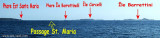
Isola La Maddalena (Arcipelago della Maddalena)

1.4nm
224°
It is the largest island of the archipelago composed of sixty islets and 7 major islands, in the NE end tip of Sardinia. It is mountainous and arid. This is the only inhabited island thoroughly.
It is connected by a bridge to Caprera island where are the house and the tomb of Garibaldi. ...
26 Nov 12
Joëlle

Golfo Di Arzachena (Sardegna)

7.2nm
172°
Gulf of Arzachena (Arsachena), located between Punta Saline and Tre Monti Cape, is a high inlet whose banks are lined with shoals.
S tip, Arzachena, W of the entrance, a beacon consists of an iron post with a sheer spherical white marks a rock particularly ...
8 Sep 12
Joëlle

Golfe de Porto Vecchio

21nm
347°
La tourelle Pecorella marque l'entrée de ce golfe qui s'enfonce à plus de 4 M dans les terres. Celle de Chiapino qui était plus au S est démolie. Il faut donc remonter suffisamment vers le N pour ne pas risquer d'en toucher les restes.
En piquant vers l'W, la balise noire délimite ...
10 Jul 20
azerty

Senetose - Tizzano

33nm
302°
SW of Corsica offers some of the most beautiful anchorages. As you get closer to Bonifacio be carreful with the weather forecast as the NW  wind can be very strong.

The range of the tide in this area is negligible. There are no regular currents along the coasts of Corse, ...
15 May 12
dd

Isola Santa Maria (Arcipelago Maddalena)

3.4nm
322°
Santa Maria is an island north of the chaplet Razzoli, Budelli and Santa Maria. It has an area of 2 km and a perimeter of ​​about 10 km.

You can anchor in the NW in Cala Muro or SE  in Cala Santa Maria.Santa Maria is separated of Razzoli by the very narrow pass degli ...
25 Nov 12
Joëlle