Cala S'Ortixeddu o Spiaggia degli americani (Teulada Sardegna)
Latitude
Longitude
DMS
---
---
DM
---
---
DD
---
---
Characteristics
Description
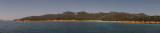
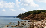
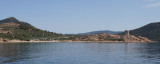
The long bay of S'Ortixeddu, called also "Americans beach", is clamped between Punta Pala di Levante tip at E and Punta Pirastu to W. Rocks protect it from the wind. This is a beautiful and wild aera where you can anchor.
2012/10/24
Update
Joëlle
La longue baie de S'Ortixeddu, dénommée la "plage des Américains", est encastrée entre la pointe Punta Pala di Levante à l'E et Punta Pirastu à l'W. Des rochers la protègent du vent. C'est un endroit magnifique et sauvage où l'on peut mouiller.
2012/10/24
Update
Joëlle
La lunga baia di S'Ortixeddu, chiamata anche "Spiaggia degli Americani", è incastonata tra Punta Pala di Levante all'E e Punta Pirastu all'W. Dei scoglieri la riparano dei venti. E' un punto magnifico e salvage dove si puo ancorare.
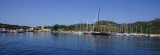
Porto Teulada is a small bay that lies in N Teulada gulf.W bay, Rossa island stands on the coast.Anchorage by 16 m . Beware to shoals tha lie NE of the Niedda point.
Portu Tramatzu is located W Teulada port, it is between two promontories and rocks that delimited at at each end, Punta Niedda to E and Punta Pala Levante to W.
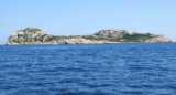
A sandy beach borders the bay and facing it is Rossa island.
Isola Rossa is 0.5 NM S Punta Niedda. It is 54 m high, red and stands out from the coast. SE of the island is shaped like a saddle, but seen from the SW only a small hill is visible.
The Port, which overlooks the narrow inlet of the old Porto Budello, is resting on the ground in the North, Northwest, West. NE it is protected by a breakwater and a quay with two arms to the South and Southeast. The first arm quay is reserved for the local fishing class. 150 ...


 The long bay of S'Ortixeddu, called also "Americans beach", is clamped between Punta Pala di Levante tip at E and Punta Pirastu to W. Rocks protect it from the wind.
 La longue baie de S'Ortixeddu, dénommée la "plage des Américains", est encastrée entre la pointe Punta Pala di Levante à l'E et Punta Pirastu à l'W. Des rochers la protègent du vent.
 La lunga baia di S'Ortixeddu, chiamata anche "Spiaggia degli Americani", è incastonata tra Punta Pala di Levante all'E e Punta Pirastu all'W. Dei scoglieri la riparano dei venti.
")
")