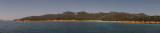
Porto Teulada is a small bay that lies in N Teulada gulf.W bay, Rossa island stands on the coast.Anchorage by 16 m . Beware to shoals tha lie NE of the Niedda point.
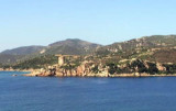
Del Budello tower, W Teulada gulf, was built by merchant Pietro Porta, in 1601, on a promontory overlooking the narrow bay of Porto Teulada, to control the entry and defend the fishpond of Teulada, located in the inner basin.
The imposing building, about 12 meters high and ...
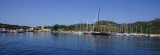
The Port, which overlooks the narrow inlet of the old Porto Budello, is resting on the ground in the North, Northwest, West. NE it is protected by a breakwater and a quay with two arms to the South and Southeast. The first arm quay is reserved for the local fishing class. 150 ...
Portu Tramatzu is located W Teulada port, it is between two promontories and rocks that delimited at at each end, Punta Niedda to E and Punta Pala Levante to W.
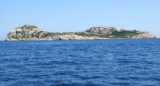
A sandy beach borders the bay and facing it is Rossa island.
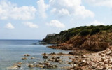
Isola Rossa is 0.5 NM S Punta Niedda. It is 54 m high, red and stands out from the coast. SE of the island is shaped like a saddle, but seen from the SW only a small hill is visible.


 Anchorage by 16 m SE Del Budello tower.
 On peut ancrer par 16 m au SE de la tour Budello.
 Si puo ancorare da 16 m allo SE dalla torre del Budello.
") Mooring possible south of the Tower.
Mooring possible south of the Tower.")