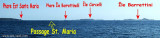
At the N end, La Presa islet forms, with S. Maria, this cove where you can find a temporary anchorage. You can anchor in Cala Muro, but attention to the many rocks and it is exposed to NW winds.
Sea bed: sand and rocks Depth: up to 2m at the entrance channel
2012/11/25
Update
Joëlle
A l'extrémitè N, l'îlot La Presa forme, avec S. Maria, cette anse où l'on peut trouver un mouillage temporaire. Vous pouvez mouiller à Cala Muro, mais attention aux nombreux rochers et elle est exposée aux vents de NW.
Fond marin: sable et rochers
Profondeur: jusqu'à 2m à l'entrée du canal
2012/11/25
Update
Joëlle
A l'estremita N, l'isolotto La Presa forma, con S. Maria, questa baia dove è possibile trovare un ancoraggio temporaneo.
Si puo ancorara a Cala di Muro, ma Attenzione ai numerosi scogli ed è esposata ai venti di NW.
It is the largest island of the archipelago composed of sixty islets and 7 major islands, in the NE end tip of Sardinia. It is mountainous and arid. This is the only inhabited island thoroughly. It is connected by a bridge to Caprera island where are the house and the tomb of Garibaldi. ...
La tourelle Pecorella marque l'entrée de ce golfe qui s'enfonce à plus de 4 M dans les terres. Celle de Chiapino qui était plus au S est démolie. Il faut donc remonter suffisamment vers le N pour ne pas risquer d'en toucher les restes. En piquant vers l'W, la balise noire délimite ...
SW of Corsica offers some of the most beautiful anchorages. As you get closer to Bonifacio be carreful with the weather forecast as the NW wind can be very strong.
The range of the tide in this area is negligible. There are no regular currents along the coasts of Corse, ...
Gulf of Arzachena (Arsachena), located between Punta Saline and Tre Monti Cape, is a high inlet whose banks are lined with shoals. S tip, Arzachena, W of the entrance, a beacon consists of an iron post with a sheer spherical white marks a rock particularly ...


 At the N end, La Presa islet forms, with S. Maria, this cove where you can find a temporary anchorage.
 A l'extrémitè N, l'îlot La Presa forme, avec S. Maria, cette anse où l'on peut trouver un mouillage temporaire.
 A l'estremita N, l'isolotto La Presa forma, con S. Maria, questa baia dove è possibile trovare un ancoraggio temporaneo.
")
")
")