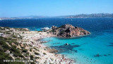
It is the largest island of the archipelago composed of sixty islets and 7 major islands, in the NE end tip of Sardinia. It is mountainous and arid. This is the only inhabited island thoroughly. It is connected by a bridge to Caprera island where are the house and the tomb of Garibaldi. ...
SW of Corsica offers some of the most beautiful anchorages. As you get closer to Bonifacio be carreful with the weather forecast as the NW wind can be very strong.
The range of the tide in this area is negligible. There are no regular currents along the coasts of Corse, ...
La tourelle Pecorella marque l'entrée de ce golfe qui s'enfonce à plus de 4 M dans les terres. Celle de Chiapino qui était plus au S est démolie. Il faut donc remonter suffisamment vers le N pour ne pas risquer d'en toucher les restes. En piquant vers l'W, la balise noire délimite ...
Gulf of Arzachena (Arsachena), located between Punta Saline and Tre Monti Cape, is a high inlet whose banks are lined with shoals. S tip, Arzachena, W of the entrance, a beacon consists of an iron post with a sheer spherical white marks a rock particularly ...
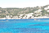
Mormorata islands consisting of two islets, are SE Marmorata tip and are surrounded by rocks.A dangerous wreck lies about 0,2 NM NNE of N islet. The passage between the islands and the mainland is obstructed by rocks.


")
")
")
 Located about 1/2 NM S of Punta Marmorata, it is easily identified by the tag it wears and that is clearly visible.
 Située à environ 1/2M au S de Punta Marmorata, elle est facilement identifiée par la balise qu'elle porte et qui se voit bien.
 Situata a circa 1/2M al S di Punta Marmorata, è facilménte identificata colla gavitello che porta e che si vede bene.
") Cala Marmorata to th North
Cala Marmorata to th North")