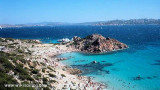
Beautiful cove on the west coast of the Maddalena, protected from the north. The surrounding area is clear.
At the bottom there is a dock.
Mooring buoys on rocky or sandy funds by 5 m.
In the southern part is another cove, a few houses and an old quarry without interest. Formerly, pink granite boulders were transported by ship across the world. The Cala Francese granite was used for the construction of the Statue of Liberty.
2012/11/27
Update
Joëlle
Belle anse sur la côte Ouest de la Maddalena, protégée du nord. Les abords sont clairs.
Au fond un ponton.
On mouillera sur les bouées, sur des fonds rocheux ou sableux par 5
m.
Dans la partie sud une autre anse, quelques maisons et une ancienne
carrière sans intérêt. Autrefois, les blocs de granit rose étaient transportés par navire à travers le monde. Le granit de cala Francese fut utilisé pour la construction de la statue de la Liberté.
2012/11/27
Update
Joëlle
Bella baia sulla costa occidentale della Maddalena, protetta a nord. La zona circostante è chiara.
In fondo c'è un pontone.
Omerragio su boe, su fondali rocciose o sabbiose, da 5 m.
Nella parte meridionale c'è un altra cala, poche case e una vecchia cava senza interessi. In precedenza, massi di granito rosa sono stati trasportati via nave in tutto il mondo. I granito di Cala Francese è stato utilizzato per la costruzione della Statua della Libertà.
It is the largest island of the archipelago composed of sixty islets and 7 major islands, in the NE end tip of Sardinia. It is mountainous and arid. This is the only inhabited island thoroughly. It is connected by a bridge to Caprera island where are the house and the tomb of Garibaldi. ...
Gulf of Arzachena (Arsachena), located between Punta Saline and Tre Monti Cape, is a high inlet whose banks are lined with shoals. S tip, Arzachena, W of the entrance, a beacon consists of an iron post with a sheer spherical white marks a rock particularly ...
La tourelle Pecorella marque l'entrée de ce golfe qui s'enfonce à plus de 4 M dans les terres. Celle de Chiapino qui était plus au S est démolie. Il faut donc remonter suffisamment vers le N pour ne pas risquer d'en toucher les restes. En piquant vers l'W, la balise noire délimite ...
SW of Corsica offers some of the most beautiful anchorages. As you get closer to Bonifacio be carreful with the weather forecast as the NW wind can be very strong.
The range of the tide in this area is negligible. There are no regular currents along the coasts of Corse, ...


")
 Beautiful cove on the west coast of the Maddalena, protected from the north. The surrounding area is clear.
 Belle anse sur la côte Ouest de la Maddalena, protégée du nord. Les abords sont clairs.
 Bella baia sulla costa occidentale della Maddalena, protetta a nord. La zona circostante è chiara.
")
")
")