Cabo de Santa Pola (C Blanca)

Cabo de Santa Pola (C Blanca)

To precisely geolocate this site. Update if necessary.

Localisation

Characteristics

Lighthouse

Description

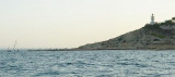
A promontory, which terminates at Cape of Santa Pola,  is marked N by a deep ravine.
The Cape of Santa Pola is located NE of the town of same name, in the province of Alicante.

Coming from S Cape marks the start of the Bay of Alicante.

The lighthouse is a tower on top of the cape, to 138 m above sea level, about 360 meters from shore.

A submarine pipeline (gas) lies 5 miles N of Cabo de Santa Pola and is marked by a lighted buoy at its seaward extremity.
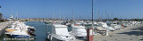
Several gas storage tanks stand near the shore of the bay, W of this terminal. It is reported (1994) that vessels up to 140m in length and 8.5m draft can be handled here.
2012/05/20
Update
Jojo
Cabo de Santa Pola (C Blanca)
Le cap San Pola vu du N
2012-05-20
Update
Jojo
Un promontoire, qui se termine au cap de Santa Pola, est marqué au N par un profond ravin.
Le cap de Santa Pola est situé au NE de la ville du même nom, dans la province d'Alicante.

En venant du S le cap marque le début de la baie d'Alicante.

Le phare se trouve sur une tour située sur le dessus du cap, à 138 m au-dessus du niveau de la mer, à environ 360 m de la rive.

Un gazoduc sous-marin (gaz) se trouve à 5 miles au N de Cabo de Santa Pola et est marqué par une bouée lumineuse à son extrémité vers le large.
Plusieurs réservoirs de stockage de gaz se tiennent près de la rive de la baie, à l'W de ce terminal. Il est rapporté (1994) que les navires jusqu'à 140m de long et 8,5 m de TE peuvent y accéder.
2012/05/20
Update
Jojo
Cabo de Santa Pola (C Blanca)
Cabo San Paola vu du large
2012-05-20
Update
Jojo
Cabo de Santa Pola (C Blanca)
2012-05-20
Update
Jojo
Ebook

Espagne Est - East Spain

  • 235 sites
  • 414 photos
  • publication date: 7 Jul 2023
  • .pdf file size: 180 Mb
Share your comments or photos on "Cabo de Santa Pola (C Blanca)"

Sites around Cabo de Santa Pola (C Blanca)

Flying distances - Direct line

Santa Pola marina (C. Valenciana)

2.5nm
238°
Santa Pola marina is located between Cabo de Santa Pola in N and Cabo Cervera in S.
Notable point: the island of Tabarca, long, narrow, low and horizontal profile. It is marked, besides the yellow tower of the lighthouse, by walls surrounding the castle of San Pablo and by a village.At ...
8 Jun 19
azerty

Ensenada de Benidorm (C Blanca)

26nm
45°
Ensenada de Benidorm lies between Cabezo del Tosal and Punta de la Escaleta, 3 miles E.  the small hill Canfali, which forms a promontory in the center of the cove of Benidorm, divides the coast into two splendid sandy beaches, the Levant and the Ponant.

This bay affords ...
20 May 12
Jojo

Marina d' Alicante (C. Valenciana)

7.7nm
11°
Only 50 meters from Alicante city centre, Marina Alicante is located inside the commercial harbour, after the outer harbor to port.
T. 965 21 36 00
F. 965 21 31 77
748b. (<50 m)

Warning: it is prohibed anchor in harbor.
20 May 12
Jojo

Marina de Las Dunas (C. Valenciana)

8.5nm
225°
The Guardamar Marina, or Las Dunas Marine, is well sheltered, located at the mouth of the Segura River, at the N of the city.
T / F. 965 971 938M. marinadelasdunas@yahoo.es494 pl. (<15 m)
8 Jun 19
azerty

Cabo de Las Huertas (C Blanca)

10nm
30°
The lighthouse is located on the tip of Las Huertas cape, overlooking the bay of San Juan beach.

Las Huertas Cape marks the end of the bay of Alicante, coming from the S.
20 May 12
Jojo