Algar de Almadraba (C Valenciana)
21nm
150°
23 May 12
Jojo
| Latitude | Longitude | |
| DMS | --- | --- |
| DM | --- | --- |
| DD | --- | --- |


 Phare Cullera
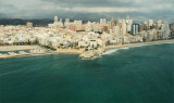
 Cullera cape is a rocky promontory which stands in the middle of flat and cultivated land. It forms the NE end of the Sierra de Cullera, arranged in ascending chain which, by far, seems an island.
It has at its end N the conical white tower of a lighthouse, and the S of the lighthouse, an old tower.
Danger: Dangerous wrecks lie 1 mile NE of Cabo Cullera and 2 miles E of Gola del Perello.
It is extended to S by the rock of Los Pensamientos, connected by a causeway to Cape.S of the promontory lies the city Cullera before which lies the bay of the same name.
From Cullera cape to Valence, the coast is low and bordered by a sandy beach. Further N, the vast lagoon of Valencia (Albufera) is separated from the sea by a sandbar. El Perello and El Perellonet are two reservoirs periodically blocked by the lagoon.
 Le cap Cullera est un promontoire rocheux qui se dresse au milieu de terrains plats et cultivés. Il forme l'extrémité NE de la sierra de Cullera, chaîne disposée en croissant qui, de loin, paraît une île.
 Il porte à son extrémité N la tour conique blanche d'un phare, et dans le S du phare, une vieille tour.
Danger: Une dangereuse épave se trouve à 1 MN au NE du cap Cullera et à 2 MN à l'E de Gola del Perello.
Il est prolongé au S par le rocher de Los Pensamientos, relié au cap par une digue.
Au S du promontoire s'étend la ville Cullera devant laquelle se trouve la rade du même nom.
Du cap Cullera à Valence, la côte est basse et bordée d'une plage de sable. Plus au N, la vaste lagune de Valence (Albufera) est séparée de la mer par une langue de sable . El Perello et El Perellonet sont les 2 réservoirs périodiquement obstrués de la lagune.
Dans la partie S de cette dernière, l'île de Palmar porte un village et une église visibles de la mer.
Au N de la lagune, de nombreux villages s'étalent jusqu'à Valence.
Toute la côte entre le cap San Antonio et Valence est saine et on peut en général l'approcher à 1 MN.
Ebook | Espagne Est - East Spain
|