Algar de la Almadraba, centered about 6 miles NW of Denia, is an extensive area of foul ground which lies off this stretch of coast. This area has depths of 25 to 36m and heavy seas are raised over it by onshore winds.
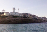
Cullera cape is a rocky promontory which stands in the middle of flat and cultivated land. It forms the NE end of the Sierra de Cullera, arranged in ascending chain which, by far, seems an island. It has at its end N the conical white tower of a lighthouse, and the S of the ...
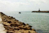
The Rio Jucar is shallow and its mouth encumbered by a bar.Two jetties extend 0.2 mile seaward from the mouth of the river. Each one have a lighthouse at 65 m from the extremity and it is recommended to pass at more than 120m from them.Rio Jucar is accessible only to small ...
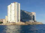
Ensenada de Benidorm lies between Cabezo del Tosal and Punta de la Escaleta, 3 miles E. the small hill Canfali, which forms a promontory in the center of the cove of Benidorm, divides the coast into two splendid sandy beaches, the Levant and the Ponant.