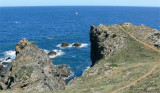
Begur (or Bagur) cape is 4 NM NNE San Sebastian cape. It consists of steep cliffs forming coves known as that of Sa Tuna.
It is marked by a lighthouse.
The dive site is located N of the Cape.
2012/07/5
Update
Jojo
Le cap Begur (ou Bagur) se trouve à 4 MN au NNE du cap San Sebastian. Il est formé de falaises escarpées formant des petites criques réputées comme celle de Sa Tuna.
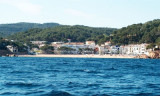
Between Del Palom point and de La Sal point, this beautiful Cala Sa Tuna, 16 to 18 m depth, houses a fihing village.Sheltered from E and S wind, we can anchor by 16 m.
Remarquable mouillage avec l'hôtel perché au dessus.Très fréquenté pendant l'été, je n'ai pas pu jeter mon ancre en août 2013, je suis allé à Sa Tuna, un peu plus haut, où il y avait aussi beaucoup de bateaux.


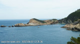


 Begur (or Bagur) cape is 4 NM NNE San Sebastian cape. It consists of steep cliffs forming coves known as that of Sa Tuna.
 Le cap Begur (ou Bagur) se trouve à 4 MN au NNE du cap San Sebastian. Il est formé de falaises escarpées formant des petites criques réputées comme celle de Sa Tuna.