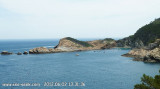
Between Del Palom point and de La Sal point, this beautiful Cala Sa Tuna, 16 to 18 m depth, houses a fihing village.Sheltered from E and S wind, we can anchor by 16 m.
Remarquable mouillage avec l'hôtel perché au dessus.Très fréquenté pendant l'été, je n'ai pas pu jeter mon ancre en août 2013, je suis allé à Sa Tuna, un peu plus haut, où il y avait aussi beaucoup de bateaux.
The Illes Medes (in Catalan) or Islas Medas (in Spanish) is a small and craggy group of islets i located close to the shore, east of the coastal town of L'Estartit. Meda Gran, the largest one, has an area of 1.8 km² and is the only island of a considerable size. It has some mediterranean ...


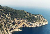
 Cabo Negre (or Las Llosas point) is N Cala Sa Tuna. It is overwhelmed by rocks.
 Cabo Negre (ou Pointe de Las Llosas) se trouve au N de Cala Sa Tuna. Il est débordé par des rochers.
")