Boca Chita Key Marina (Key Biscayne)

Boca Chita Key Marina (Key Biscayne)

To precisely geolocate this site. Update if necessary.

Localisation

Characteristics

Port
WC saltwater toilets
Lighthouse
Beach
Sand
Fishing

Description

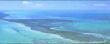
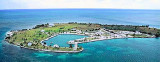
The park's most popular island provides visitors with a variety of facilities.
There is a campground with picnic tables and barbecue grills. Additional picnic tables and barbecue grills are located on the south side of the harbor near the open-air pavilion.
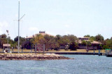
Saltwater toilets are available, but since there is no freshwater or electricity on the island, there are no sinks or showers.
A half-mile hiking trail starts just east of the restrooms. The trail continues to the south end of the island curving back north and emerging near the pavilion and picnic area.
The island's crowning glory, and Biscayne National Park's de facto symbol, is the 65-foot ornamental lighthouse built by
Mark Honeywell, one of the island's former owners, in the 1930s. The lightouse is open intermittently whenever park staff or volunteers are on the island. The observation deck provides a panoramic view of the islands, bay, ocean, and the Miami, Key.
2010/04/15
Update
Joëlle
Boca Chita Key Marina (Key Biscayne)
2010-04-15
Update
Joëlle
Boca Chita Key Marina (Key Biscayne)
2010-04-15
Update
Joëlle
Boca Chita Key Marina (Key Biscayne)
2010-04-15
Update
Joëlle
L'île la plus populaire du parc, offre aux visiteurs une variété d'équipements.
Il y a un terrain de camping avec tables de pique-nique et barbecues. Tables de pique-nique et barbecues supplémentaires sont situés sur le côté sud du port à proximité du pavillon en plein air. des toilettes à l'eau de mer sont disponibles, mais puisqu'il n'y a pas d'eau douce ou d'électricité sur l'île, il n'y a pas de puits ou de douches.
Un sentier de randonnée d'un demi-mile commence juste à l'est des toilettes. Le sentier continue vers l'extrémité sud de l'île, tourne vers le nord et arrive au pavillon et la zone de pique-nique.
Le point de mire de l'île, et le symbole de Biscayne National Park de facto, est le phare de 19,5 m construit par Mark ornementales Honeywell, l'un des anciens propriétaires de l'île, dans les années 1930. Le phare est ouvert par intermittence lorsque le personnel du parc ou des bénévoles sont sur l'île. La plate-forme d'observation offre une vue panoramique sur les îles, la baie, l'océan, et Miami.
2012/04/17
Update
JB
Ebook

Gulf of Mexico

  • 227 sites
  • 182 photos
  • publication date: 9 Jul 2023
  • .pdf file size: 78 Mb
Share your comments or photos on "Boca Chita Key Marina (Key Biscayne)"

Sites around Boca Chita Key Marina (Key Biscayne)

Flying distances - Direct line

Elliot Key (Florida)

5.2nm
197°
Elliott Key is the northernmost of the true Florida
Keys (those 'keys' which are ancient coral reefs lifted above the present sea level), and the largest key north of Key
Largo. It is located entirely within Biscayne National Park.
It is bordered by the Atlantic Ocean to ...
18 Apr 10
Joëlle

Key Biscayne (Miami)

10nm
Key Biscayne is an island located in Miami-Dade County, Florida, United States, between the Atlantic Ocean and Biscayne
Bay. It is the southernmost of the barrier islands along the Atlantic coast of Florida, and lies south of Miami Beach and southeast of Miami. The Key is connected ...
18 Apr 12
JB

Miami Beach (Florida)

18nm
Miami Beach occupies the barrier beach that separates the ocean from the upper part of Biscayne Bay and is also an important yachting center. A number of causeways, with bridges over the channels, form good highway connections with Miami and the mainland communities.
The city is ...
8 Apr 10
Joëlle

Sands Key (Biscayne NP)

1.1nm
199°
Sands Key is an island north of the upper Florida
Keys in Biscayne National Park.It is located in lower Biscayne
Bay, between Elliott Key and Boca Chita Key.
19 Apr 10
Joëlle

Boca Chita Key (Key Biscayne)

0.1nm
188°
Boca Chita is a small island that is located approximately 12 miles south of the Cape Florida lighthouse on Key
Biscayne, and Boca Chita Key is located approximately
9 miles from Convoy Point.
WARNING!!! ---
MOSQUITOES
ARE REALLY BAD OVER SUMMER MONTHS!
At one point, ...
15 Apr 10
Joëlle

Elliot Key Harbor (Biscayne NP)

4.4nm
195°
The entrance at Elliott Key harbor is approximately 2 ½ feet at low tide. Low tide is calculated by adding three hours and twenty-five minutes to the low tide at Miami's Government Cut. High tide is calculated by adding two hours and twenty-eight minutes to the high tide at Government ...
18 Apr 10
Joëlle